
Doe een donatie
Rust jezelf uit voor je volgende avontuur:
Als Amazon-partner verdient deze site een commissie op in aanmerking komende aankopen, zonder extra kosten voor jou.
Topografische kaart Pinukpuk
Klik op de kaart om de hoogte weer te geven.
Doe een donatie
Rust jezelf uit voor je volgende avontuur:
Als Amazon-partner verdient deze site een commissie op in aanmerking komende aankopen, zonder extra kosten voor jou.
Over deze kaart
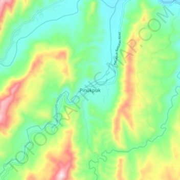
Naam: Topografische kaart Pinukpuk, hoogte, reliëf.
Gemiddelde hoogte: 246 m
Minimale hoogte: 67 m
Maximale hoogte: 602 m
Doe een donatie
Rust jezelf uit voor je volgende avontuur:
Als Amazon-partner verdient deze site een commissie op in aanmerking komende aankopen, zonder extra kosten voor jou.
Andere topografische kaarten
Klik op een kaart om zijn topografie, zijn hoogte en zijn reliëf te bekijken.
Chico River
The Chico River, has a total length of 233 kilometres (145 mi), making it the longest tributary of the Cagayan River, itself the largest river in the Philippines. For centuries it has been central to farming, trading, livelihoods, and daily life, whether as a benefit or hindrance. It provided a source of water…
Gemiddelde hoogte: 585 m
Doe een donatie
Rust jezelf uit voor je volgende avontuur:
Als Amazon-partner verdient deze site een commissie op in aanmerking komende aankopen, zonder extra kosten voor jou.
Chico River
The Chico River, has a total length of 233 kilometres (145 mi), making it the longest tributary of the Cagayan River, itself the largest river in the Philippines. For centuries it has been central to farming, trading, livelihoods, and daily life, whether as a benefit or hindrance. It provided a source of water…
Gemiddelde hoogte: 585 m