
Topografische kaart New Washoe City
Interactieve kaart
Klik op de kaart om de hoogte weer te geven.
Over deze kaart
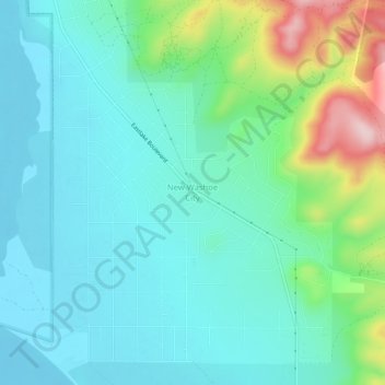
Naam: Topografische kaart New Washoe City, hoogte, reliëf.
Gemiddelde hoogte: 1.589 m
Minimale hoogte: 1.529 m
Maximale hoogte: 1.793 m
Andere topografische kaarten
Klik op een kaart om zijn topografie, zijn hoogte en zijn reliëf te bekijken.
Cold Springs
United States > Nevada > Washoe County
Cold Springs, Washoe County, Nevada, 89508, United States
Gemiddelde hoogte: 1.573 m
Nixon
United States > Nevada > Washoe County
Nixon, Washoe County, Nevada, 89424, United States
Gemiddelde hoogte: 1.209 m
Incline Village-Crystal Bay
United States > Nevada > Washoe County
Incline Village-Crystal Bay, Washoe County, Nevada, United States
Gemiddelde hoogte: 2.173 m
Reno
United States > Nevada > Washoe County
Reno, Washoe County, Nevada, United States
Gemiddelde hoogte: 1.650 m
Sparks
United States > Nevada > Washoe County
Sparks, Washoe County, Nevada, United States
Gemiddelde hoogte: 1.438 m
Oxbow Nature Study Area
United States > Nevada > Washoe County > Reno > West Reno
Oxbow Nature Study Area, West Reno, Reno, Washoe County, Nevada, United States
Gemiddelde hoogte: 1.415 m
North Valley
United States > Nevada > Washoe County > Reno
North Valley, Reno, Washoe County, Nevada, 89512, United States
Gemiddelde hoogte: 1.419 m
Pyramid Lake
United States > Nevada > Washoe County
Pyramid Lake, Washoe County, Nevada, United States
Gemiddelde hoogte: 1.406 m