
Topografische kaart Bethlehem
Interactieve kaart
Klik op de kaart om de hoogte weer te geven.
Bethlehem
According to the United States Census Bureau, the town has a total area of 91.0 square miles (235.6 km2), of which 90.6 square miles (234.7 km2) are land and 0.3 square miles (0.9 km2) are water, comprising 0.39% of the town. Bethlehem is drained by the Ammonoosuc, Gale, Zealand and Little rivers, together with Tuttle, Baker and Haystack brooks. Mount Cleveland, elevation 2,397 feet (731 m), and Mount Agassiz, 2,378 ft (725 m), rise to the south of the center of town. Town boundaries contain several of the famous 4,000-footers of New Hampshire: North Twin Mountain (the highest point in Bethlehem at 4,761 ft (1,451 m)), Mount Hale, Mount Tom, Mount Field, and Mount Willey. Bethlehem lies almost fully within the Connecticut River watershed, though a tiny portion of the southeastern corner of the town is in the Merrimack River watershed, and an even smaller portion on the eastern side of the Willey Range is in the Saco River watershed.
Over deze kaart
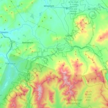
Naam: Topografische kaart Bethlehem, hoogte, reliëf.
Gemiddelde hoogte: 528 m
Minimale hoogte: 182 m
Maximale hoogte: 1.572 m
Andere topografische kaarten
Klik op een kaart om zijn topografie, zijn hoogte en zijn reliëf te bekijken.
Stinson Lake
United States > New Hampshire > Grafton County > Rumney > Stinson Lake
Gemiddelde hoogte: 460 m
Mount Kineo, East Peak
United States > New Hampshire > Grafton County > Ellsworth
Gemiddelde hoogte: 710 m
West Lebanon
United States > New Hampshire > Grafton County > Lebanon > West Lebanon
Gemiddelde hoogte: 165 m
North Littleton
United States > New Hampshire > Grafton County > Littleton > North Littleton
Gemiddelde hoogte: 333 m
LeBruns Mobile Home Park
United States > New Hampshire > Grafton County > Lebanon > LeBruns Mobile Home Park
Gemiddelde hoogte: 326 m