
Topografische kaart Saint Josephs
Interactieve kaart
Klik op de kaart om de hoogte weer te geven.
Over deze kaart
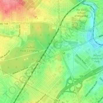
Naam: Topografische kaart Saint Josephs, hoogte, reliëf.
Locatie: Saint Josephs, Baltimore, Maryland, United States (39.27131 -76.67938 39.27711 -76.67149)
Gemiddelde hoogte: 49 m
Minimale hoogte: 11 m
Maximale hoogte: 96 m
Andere topografische kaarten
Klik op een kaart om zijn topografie, zijn hoogte en zijn reliëf te bekijken.
Baltimore
United States > Maryland > Baltimore
Baltimore, Maryland, 21233, United States
Gemiddelde hoogte: 65 m
Middle East
United States > Maryland > Baltimore
Middle East, Baltimore, Maryland, United States
Gemiddelde hoogte: 29 m
Cedarcroft
United States > Maryland > Baltimore
Cedarcroft, Baltimore, Maryland, United States
Gemiddelde hoogte: 126 m
Broadway East
United States > Maryland > Baltimore
Broadway East, Baltimore, Maryland, United States
Gemiddelde hoogte: 36 m
Woodberry
United States > Maryland > Baltimore
Woodberry, Baltimore, Maryland, United States
Gemiddelde hoogte: 94 m
Frankford
United States > Maryland > Baltimore
Frankford, Baltimore, Maryland, 21206, United States
Gemiddelde hoogte: 40 m