
Topografische kaart Blue Hill
Interactieve kaart
Klik op de kaart om de hoogte weer te geven.
Over deze kaart
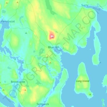
Naam: Topografische kaart Blue Hill, hoogte, reliëf.
Locatie: Blue Hill, Hancock County, Maine, United States (44.29745 -68.69667 44.50539 -68.46241)
Gemiddelde hoogte: 38 m
Minimale hoogte: -1 m
Maximale hoogte: 279 m
According to the United States Census Bureau, the town has a total area of 86.57 square miles (224.22 km2), of which 62.48 square miles (161.82 km2) is land and 24.09 square miles (62.39 km2) is water. Located on Blue Hill Bay, the town is drained by Mill Brook. Blue Hill, elevation 940 feet (287 meters), is the town's highest point. Long Island, situated in Blue Hill Bay, is part of the town.
Andere topografische kaarten
Klik op een kaart om zijn topografie, zijn hoogte en zijn reliëf te bekijken.
Gouldsboro
United States > Maine > Hancock County
Gouldsboro, Hancock County, Maine, United States
Gemiddelde hoogte: 16 m
Johns Island
United States > Maine > Hancock County > Swan's Island
Johns Island, Swan's Island, Hancock County, Maine, United States
Gemiddelde hoogte: 0 m
Sister Islands
United States > Maine > Hancock County > Swan's Island
Sister Islands, Swan's Island, Hancock County, Maine, 04635, United States
Gemiddelde hoogte: 9 m
Trenton
United States > Maine > Hancock County
Trenton, Hancock County, Maine, 04705, United States
Gemiddelde hoogte: 19 m
Turtle Island
United States > Maine > Hancock County > Winter Harbor
Turtle Island, Winter Harbor, Hancock County, Maine, United States
Gemiddelde hoogte: 1 m
Frenchboro
United States > Maine > Hancock County
Frenchboro, Hancock County, Maine, 04635, United States
Gemiddelde hoogte: 2 m
Stonington
United States > Maine > Hancock County
Stonington, Hancock County, Maine, 04681, United States
Gemiddelde hoogte: 4 m
Southwest Harbor
United States > Maine > Hancock County
Southwest Harbor, Hancock County, Maine, 04679, United States
Gemiddelde hoogte: 21 m
Franklin
United States > Maine > Hancock County
Franklin, Hancock County, Maine, 04634, United States
Gemiddelde hoogte: 52 m
Otter Cliffs
United States > Maine > Hancock County > Bar Harbor
Otter Cliffs, Bar Harbor, Hancock County, Maine, United States
Gemiddelde hoogte: 13 m
Acadia National Park
United States > Maine > Hancock County > Bar Harbor
Acadia National Park, Bar Harbor, Hancock County, Maine, 04609, United States
Gemiddelde hoogte: 9 m
Aurora
United States > Maine > Hancock County
Aurora, Hancock County, Maine, 04408, United States
Gemiddelde hoogte: 114 m
Ellsworth
United States > Maine > Hancock County > Ellsworth
Ellsworth, Hancock County, Maine, United States
Gemiddelde hoogte: 52 m
Carney Island
United States > Maine > Hancock County > Deer Isle
Carney Island, Deer Isle, Hancock County, Maine, United States
Gemiddelde hoogte: 7 m
Orland
United States > Maine > Hancock County > Orland
Orland, Hancock County, Maine, United States
Gemiddelde hoogte: 61 m
Bar Harbor
United States > Maine > Hancock County
Bar Harbor, Hancock County, Maine, 04609, United States
Gemiddelde hoogte: 33 m
Bucksport (CDP)
United States > Maine > Hancock County > Bucksport
Bucksport (CDP), Bucksport, Hancock County, Maine, 04416, United States
Gemiddelde hoogte: 46 m
Deer Isle
United States > Maine > Hancock County
Deer Isle, Hancock County, Maine, United States
Gemiddelde hoogte: 10 m
Mount Desert
United States > Maine > Hancock County
Mount Desert, Hancock County, Maine, United States
Gemiddelde hoogte: 31 m
Saint Helena Island
United States > Maine > Hancock County > Stonington
Saint Helena Island, Stonington, Hancock County, Maine, 04682, United States
Gemiddelde hoogte: 12 m