Geolokaliseren

Topografische kaart Lorimer Lake

Interactieve kaart

Klik op de kaart om de hoogte weer te geven.

Over deze kaart

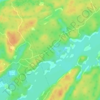
Naam: Topografische kaart Lorimer Lake, hoogte, reliëf.

Locatie: Lorimer Lake, Whitestone, Parry Sound District, Central Ontario, Ontario, Canada (45.53631 -79.98459 45.55631 -79.96459)

Gemiddelde hoogte: 256 m

Minimale hoogte: 240 m

Maximale hoogte: 273 m

Andere topografische kaarten

Klik op een kaart om zijn topografie, zijn hoogte en zijn reliëf te bekijken.

Whitestone

Canada > Ontario > Parry Sound District > Whitestone

Whitestone, Parry Sound District, Central Ontario, Ontario, P0A 1G0, Canada

Gemiddelde hoogte: 249 m

Wahwashkesh

Canada > Ontario > Parry Sound District > Whitestone

Wahwashkesh, Whitestone, Parry Sound District, Central Ontario, Ontario, Canada

Gemiddelde hoogte: 230 m

Wahwashkesh Lake

Canada > Ontario > Parry Sound District > Whitestone

Wahwashkesh Lake, Whitestone, Parry Sound District, Central Ontario, Ontario, Canada

Gemiddelde hoogte: 237 m

Whitestone Lake

Canada > Ontario > Parry Sound District > Whitestone > Dunchurch

Whitestone Lake, Dunchurch, Whitestone, Parry Sound District, Central Ontario, Ontario, Canada

Gemiddelde hoogte: 269 m

Bolger Lake

Canada > Ontario > Parry Sound District > Whitestone

Bolger Lake, Whitestone, Parry Sound District, Central Ontario, Ontario, Canada

Gemiddelde hoogte: 237 m

Shanty Bay

Canada > Ontario > Parry Sound District > Whitestone

Shanty Bay, Whitestone, Parry Sound District, Central Ontario, Ontario, Canada

Gemiddelde hoogte: 232 m