
Topografische kaart Suez Canal
Interactieve kaart
Klik op de kaart om de hoogte weer te geven.
Over deze kaart
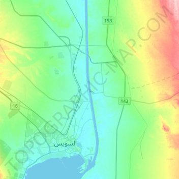
Naam: Topografische kaart Suez Canal, hoogte, reliëf.
Locatie: Suez Canal, Suez, Egypt (29.92639 32.55958 30.16442 32.58845)
Gemiddelde hoogte: 39 m
Minimale hoogte: -3 m
Maximale hoogte: 161 m
Despite the construction challenges that could have been the result of the alleged difference in sea levels, the idea of finding a shorter route to the east remained alive. In 1830, General Francis Chesney submitted a report to the British government that stated that there was no difference in elevation and that the Suez Canal was feasible, but his report received no further attention. Lieutenant Waghorn established his "Overland Route", which transported post and passengers to India via Egypt.
Andere topografische kaarten
Klik op een kaart om zijn topografie, zijn hoogte en zijn reliëf te bekijken.
Izbat Tall al Hajaj
Izbat Tall al Hajaj, Suez, 43515, Egypt
Gemiddelde hoogte: 10 m