
Topografische kaart Chruślice
Interactieve kaart
Klik op de kaart om de hoogte weer te geven.
Over deze kaart
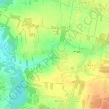
Naam: Topografische kaart Chruślice, hoogte, reliëf.
Gemiddelde hoogte: 186 m
Minimale hoogte: 165 m
Maximale hoogte: 203 m
Andere topografische kaarten
Klik op een kaart om zijn topografie, zijn hoogte en zijn reliëf te bekijken.
Janów
Poland > Masovian Voivodeship > Radom County > Sławno
Janów, Sławno, gmina Wolanów, Radom County, Masovian Voivodeship, 26-652, Poland
Gemiddelde hoogte: 192 m
Kosów Mniejszy
Poland > Masovian Voivodeship > Radom County > Kosów
Kosów Mniejszy, Kosów, gmina Kowala, Radom County, Masovian Voivodeship, 26-624, Poland
Gemiddelde hoogte: 194 m