
Topografische kaart Harristown
Interactieve kaart
Klik op de kaart om de hoogte weer te geven.
Over deze kaart
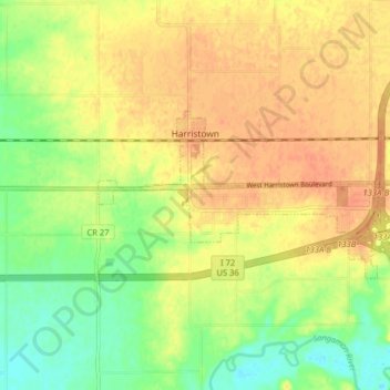
Naam: Topografische kaart Harristown, hoogte, reliëf.
Locatie: Harristown, Macon County, Illinois, 62537, United States (39.83109 -89.10394 39.85750 -89.02406)
Gemiddelde hoogte: 200 m
Minimale hoogte: 177 m
Maximale hoogte: 217 m
Andere topografische kaarten
Klik op een kaart om zijn topografie, zijn hoogte en zijn reliëf te bekijken.
Elwin
United States > Illinois > Macon County
Elwin, Macon County, Illinois, 62532, United States
Gemiddelde hoogte: 216 m
Big Creek Park
United States > Illinois > Macon County > Decatur
Big Creek Park, Decatur, Macon County, Illinois, United States
Gemiddelde hoogte: 201 m
Decatur
United States > Illinois > Macon County
Decatur, Macon County, Illinois, United States
Gemiddelde hoogte: 205 m
Forsyth
United States > Illinois > Macon County > Forsyth
Forsyth, Macon County, Illinois, 62535, United States
Gemiddelde hoogte: 206 m