
Topografische kaart Hawkesbury
Interactieve kaart
Klik op de kaart om de hoogte weer te geven.
Over deze kaart
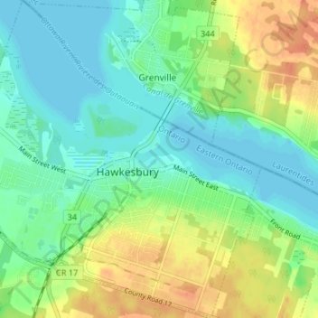
Naam: Topografische kaart Hawkesbury, hoogte, reliëf.
Gemiddelde hoogte: 52 m
Minimale hoogte: 38 m
Maximale hoogte: 78 m
Andere topografische kaarten
Klik op een kaart om zijn topografie, zijn hoogte en zijn reliëf te bekijken.
Embrun
Canada > Ontario > Prescott and Russell Counties
Embrun, Russell, Prescott and Russell Counties, Eastern Ontario, Ontario, K0A 1W1, Canada
Gemiddelde hoogte: 69 m
Alfred and Plantagenet
Canada > Ontario > Prescott and Russell Counties
Alfred and Plantagenet, Prescott and Russell Counties, Eastern Ontario, Ontario, Canada
Gemiddelde hoogte: 71 m
Voyageur Provincial Park
Canada > Ontario > Prescott and Russell Counties > East Hawkesbury
Voyageur Provincial Park, East Hawkesbury, Prescott and Russell Counties, Eastern Ontario, Ontario, K0B 1B0, Canada
Gemiddelde hoogte: 45 m
Limoges
Canada > Ontario > Prescott and Russell Counties > The Nation > Limoges
Limoges, The Nation, Prescott and Russell Counties, Eastern Ontario, Ontario, K0A 2M0, Canada
Gemiddelde hoogte: 71 m
St-Eugène
Canada > Ontario > Prescott and Russell Counties > East Hawkesbury > St-Eugène
St-Eugène, East Hawkesbury, Prescott and Russell Counties, Eastern Ontario, Ontario, K0B 1P0, Canada
Gemiddelde hoogte: 59 m
Clarence-Rockland
Canada > Ontario > Prescott and Russell Counties > Clarence-Rockland
Clarence-Rockland, Prescott and Russell Counties, Eastern Ontario, Ontario, Canada
Gemiddelde hoogte: 71 m
The Nation
Canada > Ontario > Prescott and Russell Counties > The Nation
The Nation, Prescott and Russell Counties, Eastern Ontario, Ontario, Canada
Gemiddelde hoogte: 72 m