
Topografische kaart Camden
Interactieve kaart
Klik op de kaart om de hoogte weer te geven.
Over deze kaart
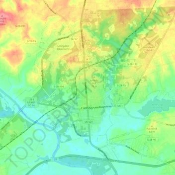
Naam: Topografische kaart Camden, hoogte, reliëf.
Locatie: Camden, Kershaw County, South Carolina, United States (34.21628 -80.65768 34.30000 -80.53743)
Gemiddelde hoogte: 68 m
Minimale hoogte: 35 m
Maximale hoogte: 123 m
Andere topografische kaarten
Klik op een kaart om zijn topografie, zijn hoogte en zijn reliëf te bekijken.
Kirkover Hills
United States > South Carolina > Kershaw County > Camden
Kirkover Hills, Camden, Kershaw County, South Carolina, 29020, United States
Gemiddelde hoogte: 72 m
Elgin
United States > South Carolina > Kershaw County
Elgin, Kershaw County, South Carolina, United States
Gemiddelde hoogte: 104 m
Sunnyhill
United States > South Carolina > Kershaw County > Camden > Sunnyhill
Sunnyhill, Camden, Kershaw County, South Carolina, 29020, United States
Gemiddelde hoogte: 86 m
Lugoff
United States > South Carolina > Kershaw County
Lugoff, Kershaw County, South Carolina, United States
Gemiddelde hoogte: 69 m