
Topografische kaart Loxton North
Interactieve kaart
Klik op de kaart om de hoogte weer te geven.
Over deze kaart
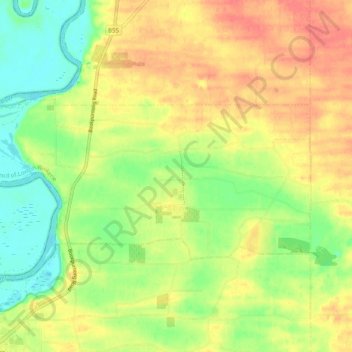
Naam: Topografische kaart Loxton North, hoogte, reliëf.
Gemiddelde hoogte: 37 m
Minimale hoogte: 9 m
Maximale hoogte: 63 m
Andere topografische kaarten
Klik op een kaart om zijn topografie, zijn hoogte en zijn reliëf te bekijken.
Bookpurnong
Australia > South Australia > The District Council of Loxton Waikerie
Bookpurnong, The District Council of Loxton Waikerie, South Australia, 5333, Australia
Gemiddelde hoogte: 37 m
Ramco
Australia > South Australia > The District Council of Loxton Waikerie
Ramco, The District Council of Loxton Waikerie, South Australia, 5322, Australia
Gemiddelde hoogte: 29 m
Loxton
Australia > South Australia > The District Council of Loxton Waikerie > Loxton
Loxton, The District Council of Loxton Waikerie, South Australia, 5333, Australia
Gemiddelde hoogte: 37 m