
Topografische kaart Suez Canal
Interactieve kaart
Klik op de kaart om de hoogte weer te geven.
Over deze kaart
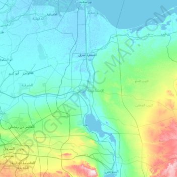
Naam: Topografische kaart Suez Canal, hoogte, reliëf.
Locatie: Suez Canal, Port Said, 43522, Egypt (29.93034 32.30378 31.27571 32.58750)
Gemiddelde hoogte: 106 m
Minimale hoogte: -6 m
Maximale hoogte: 869 m
Although the alleged difference in sea levels could be problematic for construction, the idea of finding a shorter route to the east remained alive. In 1830, F. R. Chesney submitted a report to the British government that stated that there was no difference in elevation and that the Suez Canal was feasible, but his report received no further attention. Lieutenant Waghorn established his "Overland Route", which transported post and passengers to India via Egypt.
Andere topografische kaarten
Klik op een kaart om zijn topografie, zijn hoogte en zijn reliëf te bekijken.
Al-ʿAbbāsiyyah Canal
Al-ʿAbbāsiyyah Canal, Port Said, 41524, Egypt
Gemiddelde hoogte: 16 m