
Topografische kaart North Stonington
Interactieve kaart
Klik op de kaart om de hoogte weer te geven.
Over deze kaart
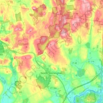
Naam: Topografische kaart North Stonington, hoogte, reliëf.
Gemiddelde hoogte: 78 m
Minimale hoogte: 3 m
Maximale hoogte: 163 m
Andere topografische kaarten
Klik op een kaart om zijn topografie, zijn hoogte en zijn reliëf te bekijken.
Mashantucket
United States > Connecticut > New London County > Ledyard > Mashantucket
Mashantucket, Ledyard, New London County, Connecticut, United States
Gemiddelde hoogte: 65 m
Colchester
United States > Connecticut > New London County > Colchester
Colchester, New London County, Connecticut, United States
Gemiddelde hoogte: 132 m
Waterford
United States > Connecticut > New London County > Waterford
Waterford, New London County, Connecticut, 06385, United States
Gemiddelde hoogte: 35 m
Sprague
United States > Connecticut > New London County > Sprague
Sprague, New London County, Connecticut, United States
Gemiddelde hoogte: 77 m
Town Open Space (Roxbury & Romagna Roads)
United States > Connecticut > New London County > East Lyme > Niantic
Town Open Space (Roxbury & Romagna Roads), Niantic, East Lyme, New London County, Connecticut, United States
Gemiddelde hoogte: 26 m
Griswold
United States > Connecticut > New London County > Griswold
Griswold, New London County, Connecticut, United States
Gemiddelde hoogte: 70 m
Poquonock Bridge
United States > Connecticut > New London County > Groton > Poquonock Bridge
Poquonock Bridge, Groton, New London County, Connecticut, United States
Gemiddelde hoogte: 15 m