
Topografische kaart Brookings County
Interactieve kaart
Klik op de kaart om de hoogte weer te geven.
Over deze kaart
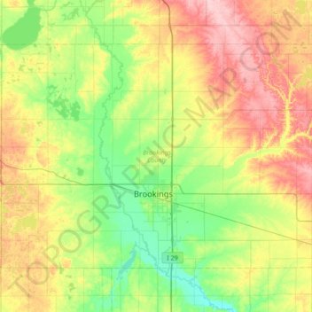
Naam: Topografische kaart Brookings County, hoogte, reliëf.
Locatie: Brookings County, South Dakota, United States (44.19593 -97.12974 44.54378 -96.45182)
Gemiddelde hoogte: 525 m
Minimale hoogte: 472 m
Maximale hoogte: 617 m
Brookings County is on the east side of South Dakota. Its east boundary line abuts the west boundary line of the state of Minnesota. The Big Sioux River flows south-southeastward through the east central part of the county; its point of entry into Moody County marks Brookings County's lowest elevation: 1,568' (478m) ASL.
Andere topografische kaarten
Klik op een kaart om zijn topografie, zijn hoogte en zijn reliëf te bekijken.
Brookings
United States > South Dakota > Brookings County
Brookings, Brookings County, South Dakota, United States
Gemiddelde hoogte: 495 m