
Topografische kaart Oughterard
Interactieve kaart
Klik op de kaart om de hoogte weer te geven.
Over deze kaart
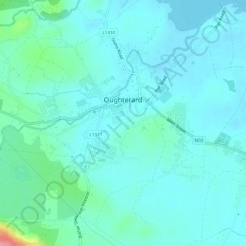
Naam: Topografische kaart Oughterard, hoogte, reliëf.
Gemiddelde hoogte: 19 m
Minimale hoogte: 5 m
Maximale hoogte: 98 m
Andere topografische kaarten
Klik op een kaart om zijn topografie, zijn hoogte en zijn reliëf te bekijken.
Aran Islands
Aran Islands, Conamara Municipal District, County Galway, Connacht, Ireland
Gemiddelde hoogte: 3 m
Ardnacross Island
Ardnacross Island, Knockboy ED, Conamara Municipal District, County Galway, Connacht, Ireland
Gemiddelde hoogte: 1 m
Rosroe
Rosroe, Moyrus ED, Conamara Municipal District, County Galway, Connacht, Ireland
Gemiddelde hoogte: 9 m
Athenry
Athenry, Athenry-Oranmore Municipal District, County Galway, Connacht, Ireland
Gemiddelde hoogte: 42 m
Ballinasloe
Ballinasloe, County Galway, Connacht, Ireland
Gemiddelde hoogte: 46 m
Curraghboy
Curraghboy, Castleffrench ED, Ballinasloe Municipal District, County Galway, Connacht, Ireland
Gemiddelde hoogte: 53 m
Ballyconneely
Ballyconneely, Conamara Municipal District, County Galway, Connacht, Ireland
Gemiddelde hoogte: 8 m
Ross Lake
Ross Lake, Sliabh an Aonaigh, Conamara Municipal District, County Galway, Connacht, Ireland
Gemiddelde hoogte: 17 m
Beagh ED
Beagh ED, Loughrea Municipal District, County Galway, Connacht, Ireland
Gemiddelde hoogte: 34 m
Glenamaddy
Glenamaddy, Ballinasloe Municipal District, County Galway, Connacht, Ireland
Gemiddelde hoogte: 85 m
Abbeyfield
Abbeyfield, Kilconnell ED, Ballinasloe Municipal District, County Galway, Connacht, Ireland
Gemiddelde hoogte: 92 m
Dunmore
Dunmore, Tuam Municipal District, County Galway, Connacht, Ireland
Gemiddelde hoogte: 63 m
Gleninagh (Moyrus)
Gleninagh (Moyrus), Bencorr ED, Conamara Municipal District, County Galway, Connacht, Ireland
Gemiddelde hoogte: 244 m
Gorterwulla
Gorterwulla, Letterfore ED, Conamara Municipal District, County Galway, Connacht, Ireland
Gemiddelde hoogte: 36 m
Milltown
Milltown, Shankill ED, Ballinasloe Municipal District, County Galway, Connacht, Ireland
Gemiddelde hoogte: 82 m
Gort
Gort, Gort ED, Loughrea Municipal District, County Galway, Connacht, Ireland
Gemiddelde hoogte: 25 m
Weir Village
Weir Village, Clarinbridge ED, Loughrea Municipal District, County Galway, Connacht, Ireland
Gemiddelde hoogte: 9 m
Loughrea Municipal District
Loughrea Municipal District, County Galway, Connacht, Ireland
Gemiddelde hoogte: 69 m
Dunmore
Dunmore, Dunmore South ED, Tuam Municipal District, County Galway, Connacht, Ireland
Gemiddelde hoogte: 62 m
Dunsandle
Dunsandle, Kilconierin ED, Loughrea Municipal District, County Galway, Connacht, Ireland
Gemiddelde hoogte: 46 m
Inverin
Inverin, Conamara Municipal District, County Galway, Connacht, Ireland
Gemiddelde hoogte: 24 m
Clifden
Clifden, Clifden ED, Conamara Municipal District, County Galway, Connacht, Ireland
Gemiddelde hoogte: 52 m
Tynagh
Tynagh, Loughrea Municipal District, County Galway, Connacht, Ireland
Gemiddelde hoogte: 65 m
Athenry-Oranmore Municipal District
Athenry-Oranmore Municipal District, County Galway, Connacht, Ireland
Gemiddelde hoogte: 42 m
Tuam Municipal District
Tuam Municipal District, County Galway, Connacht, Ireland
Gemiddelde hoogte: 54 m
Galway Bay
Galway Bay, County Galway, Connacht, Ireland
Gemiddelde hoogte: 35 m
Aughrim
Aughrim, Ballinasloe Municipal District, County Galway, Connacht, Ireland
Gemiddelde hoogte: 68 m
Moycullen
Moycullen, Moycullen ED, Conamara Municipal District, County Galway, Connacht, Ireland
Gemiddelde hoogte: 10 m
Banagher
Banagher, Doonbally ED, Tuam Municipal District, County Galway, Connacht, Ireland
Gemiddelde hoogte: 47 m
Killimor
Killimor, Killimor ED, Athenry-Oranmore Municipal District, County Galway, Connacht, Ireland
Gemiddelde hoogte: 72 m
Oughterard ED
Oughterard ED, Conamara Municipal District, County Galway, Connacht, H91 CVY3, Ireland
Gemiddelde hoogte: 89 m
Rabbit Island
Rabbit Island, Eanach Dhúin, Athenry-Oranmore Municipal District, County Galway, Connacht, Ireland
Gemiddelde hoogte: 6 m
Lackagh Beg
Lackagh Beg, Lackaghbeg ED, Athenry-Oranmore Municipal District, County Galway, Connacht, Ireland
Gemiddelde hoogte: 33 m
Marley
Marley, Killeen ED, Tuam Municipal District, County Galway, Connacht, Ireland
Gemiddelde hoogte: 60 m
Inchamore
Inchamore, Ballycahalan ED, Loughrea Municipal District, County Galway, Connacht, Ireland
Gemiddelde hoogte: 110 m
Gortnagroagh
Gortnagroagh, Wormhole ED, Conamara Municipal District, County Galway, Connacht, Ireland
Gemiddelde hoogte: 23 m
Ballinasloe Municipal District
Ballinasloe Municipal District, County Galway, Connacht, Ireland
Gemiddelde hoogte: 66 m
Dooghta
Dooghta, Cong ED, Conamara Municipal District, County Galway, Connacht, Ireland
Gemiddelde hoogte: 89 m
Kylemore
Kylemore, Loughrea Municipal District, County Galway, Connacht, Ireland
Gemiddelde hoogte: 45 m
Galway
Ireland > County Galway > Galway
Galway, Galway City, County Galway, Connacht, H91 D328, Ireland
Gemiddelde hoogte: 26 m
Claregalway
Ireland > County Galway > Claregalway
Claregalway, Athenry-Oranmore Municipal District, County Galway, Connacht, H91H6K7, Ireland
Gemiddelde hoogte: 16 m
Inishbofin
Inishbofin, Conamara Municipal District, County Galway, Connacht, Ireland
Gemiddelde hoogte: 7 m
Corrandulla
Corrandulla, Eanach Dhúin, Athenry-Oranmore Municipal District, County Galway, Connacht, Ireland
Gemiddelde hoogte: 17 m
Kilroe East
Kilroe East, Cill Ainnín, Conamara Municipal District, County Galway, Connacht, Ireland
Gemiddelde hoogte: 40 m
Woodford
Ireland > County Galway > Woodford
Woodford, Loughrea Municipal District, County Galway, Connacht, Ireland
Gemiddelde hoogte: 91 m
Lismoes
Lismoes, Mounthazel ED, Ballinasloe Municipal District, County Galway, Connacht, Ireland
Gemiddelde hoogte: 92 m
Galway City
Galway City, Conamara Municipal District, County Galway, Connacht, Ireland
Gemiddelde hoogte: 15 m
Conamara Municipal District
Conamara Municipal District, County Galway, Connacht, Ireland
Gemiddelde hoogte: 51 m
Lough Corrib
Lough Corrib, County Galway, Connacht, Ireland
Gemiddelde hoogte: 46 m
Moylough
Moylough, Ballinasloe Municipal District, County Galway, Connacht, H53 D851, Ireland
Gemiddelde hoogte: 78 m