
Topografische kaart Canyonlands National Park - Maze District
Interactieve kaart
Klik op de kaart om de hoogte weer te geven.
Over deze kaart
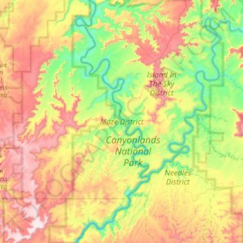
Naam: Topografische kaart Canyonlands National Park - Maze District, hoogte, reliëf.
Gemiddelde hoogte: 1.546 m
Minimale hoogte: 1.156 m
Maximale hoogte: 2.162 m
Andere topografische kaarten
Klik op een kaart om zijn topografie, zijn hoogte en zijn reliëf te bekijken.
Long Valley Junction
USA > Utah > Long Valley Junction
Long Valley Junction, Kane County, Utah, 84710, USA
Gemiddelde hoogte: 2.295 m
Thousand Lake Mountain
Thousand Lake Mountain, Wayne County, Utah, USA
Gemiddelde hoogte: 3.341 m
Haystack Lake
Haystack Lake, Lakes Country Trail, Summit County, Utah, USA
Gemiddelde hoogte: 3.067 m
Capitol Hill
USA > Utah > Salt Lake City
Capitol Hill, Salt Lake City, Salt Lake County, Utah, 84103, USA
Gemiddelde hoogte: 1.510 m
La Sal Mountains Viewpoint
La Sal Mountains Viewpoint, Arches Entrance Road, Grand County, Utah, 84532-2134, USA
Gemiddelde hoogte: 1.347 m
Browns Park
Browns Park, Bountiful, Davis County, Utah, 84010, USA
Gemiddelde hoogte: 1.556 m
Timpanogos Glacier
USA > Utah > Aspen Grove
Timpanogos Glacier, Mount Timpanogos Trail #052, Aspen Grove, Utah County, Utah, USA
Gemiddelde hoogte: 3.148 m
Gladys Lake
Gladys Lake, Head of Rock Creek Trail, Duchesne County, Utah, USA
Gemiddelde hoogte: 3.385 m
Little Bear River
Little Bear River, Cache County, Utah, 84319, USA
Gemiddelde hoogte: 1.475 m
Canyonlands National Park
Canyonlands National Park, Wayne County, Utah, USA
Gemiddelde hoogte: 1.640 m