
Topografische kaart Dillon
Interactieve kaart
Klik op de kaart om de hoogte weer te geven.
Over deze kaart
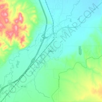
Naam: Topografische kaart Dillon, hoogte, reliëf.
Locatie: Dillon, Beaverhead County, Montana, United States (45.17412 -112.67461 45.25412 -112.59461)
Gemiddelde hoogte: 1.592 m
Minimale hoogte: 1.530 m
Maximale hoogte: 1.779 m
Dillon is located at 45°12′57″N 112°38′3″W / 45.21583°N 112.63417°W / 45.21583; -112.63417 (45.215735, -112.634055), approximately 40 miles (64 km) east of the Continental Divide. It lies at an elevation of 5,102 feet (1,555 m).