
Topografische kaart Rio Grande
Interactieve kaart
Klik op de kaart om de hoogte weer te geven.
Over deze kaart
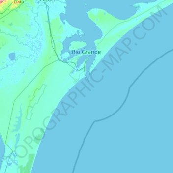
Naam: Topografische kaart Rio Grande, hoogte, reliëf.
Gemiddelde hoogte: 3 m
Minimale hoogte: -3 m
Maximale hoogte: 257 m
Rio Grande, as the name suggests, is a littoral city, which boasts what many call the longest beach in the world — Praia do Cassino. This beach is approximately 250 km (160 mi) of uninterrupted Atlantic coastline. The entire municipality lies at a very low altitude — at its highest point only 10 meters (33 feet) above sea level. Additionally, the city, which is surrounded by water, sinks about one centimeter every year.
Andere topografische kaarten
Klik op een kaart om zijn topografie, zijn hoogte en zijn reliëf te bekijken.
Pelotas
Brazil > Rio Grande do Sul > Aglomeração Urbana do Sul > Pelotas
Pelotas, Região Geográfica Imediata de Pelotas, Aglomeração Urbana do Sul, Região Geográfica Intermediária de Pelotas, Rio Grande do Sul, 96015-000, Brazil
Gemiddelde hoogte: 18 m