
Topografische kaart Raynesford
Interactieve kaart
Klik op de kaart om de hoogte weer te geven.
Over deze kaart
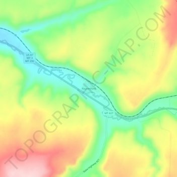
Naam: Topografische kaart Raynesford, hoogte, reliëf.
Gemiddelde hoogte: 1.305 m
Minimale hoogte: 1.200 m
Maximale hoogte: 1.425 m
Raynesford is an unincorporated community in Judith Basin County, Montana, United States. Its elevation is 4,042 feet (1,232 m), and it is located at 47°16′12″N 110°43′48″W / 47.27000°N 110.73000°W / 47.27000; -110.73000 (47.2699643, -110.7299417). The community includes a community center, a catholic church, a fire department, and a post office. The post office was established under the name of "Spion Kop" on March 31, 1906; its name was changed to Raynesford exactly three years later.
Andere topografische kaarten
Klik op een kaart om zijn topografie, zijn hoogte en zijn reliëf te bekijken.
Stanford
United States > Montana > Judith Basin County
Stanford, Judith Basin County, Montana, 59579, United States
Gemiddelde hoogte: 1.304 m