
Topografische kaart Ballyliffin
Interactieve kaart
Klik op de kaart om de hoogte weer te geven.
Over deze kaart
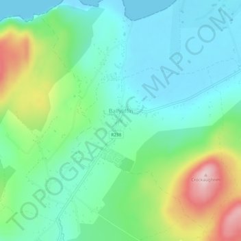
Naam: Topografische kaart Ballyliffin, hoogte, reliëf.
Gemiddelde hoogte: 76 m
Minimale hoogte: -1 m
Maximale hoogte: 266 m
Andere topografische kaarten
Klik op een kaart om zijn topografie, zijn hoogte en zijn reliëf te bekijken.
Clonmany
Clonmany, Inishowen Municipal District, County Donegal, F93 RRX6, Ireland
Gemiddelde hoogte: 47 m
Cruit Island
Cruit Island, Rutland ED, Glenties Municipal District, County Donegal, Ireland
Gemiddelde hoogte: 6 m
Lisfannan
Lisfannan, Burt ED, Inishowen Municipal District, County Donegal, Ireland
Gemiddelde hoogte: 48 m
Murvagh Lower
Murvagh Lower, Ballintra ED, Donegal Municipal District, County Donegal, Ireland
Gemiddelde hoogte: 2 m
Dunfanaghy
Dunfanaghy, County Donegal, F92 H0CY, Ireland
Gemiddelde hoogte: 23 m
Croaghross
Ireland > County Donegal > Letterkenny
Croaghross, Greenfort ED, Letterkenny, County Donegal, Ireland
Gemiddelde hoogte: 25 m
Crocknafeola
Crocknafeola, Killybegs ED, Donegal Municipal District, County Donegal, Ireland
Gemiddelde hoogte: 111 m
Carndonagh
Carndonagh, Inishowen Municipal District, County Donegal, Ireland
Gemiddelde hoogte: 54 m
Glenveagh National Park
Glenveagh National Park, Drumnalifferny Mountain, Dunlewy ED, Glenties Municipal District, County Donegal, Ulster, Ireland
Gemiddelde hoogte: 200 m
Greencastle
Greencastle, Inishowen Municipal District, County Donegal, Ireland
Gemiddelde hoogte: 46 m
Rosapenna
Ireland > County Donegal > Letterkenny
Rosapenna, Rosguill ED, Letterkenny, County Donegal, Ireland
Gemiddelde hoogte: 11 m
Corkey
Ireland > County Donegal > Letterkenny
Corkey, Kincraigy ED, Letterkenny, County Donegal, Ireland
Gemiddelde hoogte: 36 m
Donegal
Ireland > County Donegal > Donegal
Donegal, Donegal Municipal District, County Donegal, F94 P028, Ireland
Gemiddelde hoogte: 48 m
Ards Big
Ireland > County Donegal > Letterkenny
Ards Big, Rathmelton ED, Letterkenny, County Donegal, Ulster, Ireland
Gemiddelde hoogte: 62 m
Glenties
Glenties, Glenties ED, Glenties Municipal District, County Donegal, Ulster, F94 KX93, Ireland
Gemiddelde hoogte: 67 m
Alt Upper
Alt Upper, Urney West ED, Lifford-Stranorlar Municipal District, County Donegal, Ulster, Ireland
Gemiddelde hoogte: 142 m
Egglybane
Egglybane, Cloghard ED, Lifford-Stranorlar Municipal District, County Donegal, Ulster, Ireland
Gemiddelde hoogte: 141 m
Carrowkeel
Carrowkeel, County Donegal, Ulster, F92 PP6R, Ireland
Gemiddelde hoogte: 50 m
Drumcarbit
Drumcarbit, Malin ED, Inishowen Municipal District, County Donegal, Ulster, Ireland
Gemiddelde hoogte: 71 m
Cashel
Cashel, Donegal Municipal District, County Donegal, Ireland
Gemiddelde hoogte: 108 m
Maum
Maum, Glenties Municipal District, County Donegal, Ulster, Ireland
Gemiddelde hoogte: 179 m
Raphoe
Raphoe, Lifford-Stranorlar Municipal District, County Donegal, Ulster, Ireland
Gemiddelde hoogte: 87 m
Glengesh
Glengesh, Glengesh ED, Glenties Municipal District, County Donegal, Ireland
Gemiddelde hoogte: 217 m
Malin Head
Malin Head, Ardmalin ED, Inishowen Municipal District, County Donegal, Ireland
Gemiddelde hoogte: 4 m
Gortlee
Ireland > County Donegal > Letterkenny
Gortlee, Letterkenny Rural ED, Letterkenny, County Donegal, Ulster, Ireland
Gemiddelde hoogte: 34 m
Burt
Burt, Inishowen Municipal District, County Donegal, Ulster, Ireland
Gemiddelde hoogte: 87 m
Sheskinarone
Sheskinarone, Dunglow ED, Glenties Municipal District, County Donegal, Ireland
Gemiddelde hoogte: 43 m
Dunfanaghy
Dunfanaghy, Dunfanaghy Electoral Division, Glenties Municipal District, County Donegal, Ulster, F92 H0CY, Ireland
Gemiddelde hoogte: 21 m
Donegal Municipal District
Donegal Municipal District, County Donegal, Ulster, Ireland
Gemiddelde hoogte: 120 m
Inishowen Municipal District
Inishowen Municipal District, County Donegal, Ireland
Gemiddelde hoogte: 59 m
Carndonagh
Ireland > County Donegal > Carndonagh
Carndonagh, Inishowen Municipal District, County Donegal, F93 XD74, Ireland
Gemiddelde hoogte: 78 m
Oort
Oort, Gleneely ED, Inishowen Municipal District, County Donegal, Ireland
Gemiddelde hoogte: 86 m
Kilmacrennan
Ireland > County Donegal > Kilmacrennan
Kilmacrennan, County Donegal, Ireland
Gemiddelde hoogte: 63 m
Mamore Gap
Mamore Gap, Urris Hills Trail, Dunaff ED, Inishowen Municipal District, County Donegal, Ireland
Gemiddelde hoogte: 192 m
Letterkenny
Letterkenny, County Donegal, Ulster, Ireland
Gemiddelde hoogte: 92 m
Stroove
Ireland > County Donegal > Stroove
Stroove, Greencastle ED, Inishowen Municipal District, County Donegal, Ireland
Gemiddelde hoogte: 56 m
Diamond
Diamond, Knock ED, Lifford-Stranorlar Municipal District, County Donegal, F93 Y27K, Ireland
Gemiddelde hoogte: 142 m
Annagry
Ireland > County Donegal > Annagry
Annagry, Glenties Municipal District, County Donegal, Ireland
Gemiddelde hoogte: 32 m
Moyle
Ireland > County Donegal > Letterkenny
Moyle, Ballyarr ED, Letterkenny, County Donegal, Ireland
Gemiddelde hoogte: 55 m
Slieve League
Slieve League, Donegal Municipal District, County Donegal, Ireland
Gemiddelde hoogte: 233 m
Errigal
Errigal, Glenties Municipal District, County Donegal, Ireland
Gemiddelde hoogte: 295 m
Gweedore
Gweedore, Glenties Municipal District, County Donegal, Ireland
Gemiddelde hoogte: 131 m
Dunfanaghy
Ireland > County Donegal > Dunfanaghy
Dunfanaghy, Glenties Municipal District, County Donegal, F92 H0CY, Ireland
Gemiddelde hoogte: 45 m
Aghadowey
Aghadowey, Ballintra ED, Donegal Municipal District, County Donegal, Ireland
Gemiddelde hoogte: 101 m
Lough Eske
Lough Eske, Lough Eask ED, Donegal Municipal District, County Donegal, Ireland
Gemiddelde hoogte: 68 m