
Topografische kaart Forest City
Interactieve kaart
Klik op de kaart om de hoogte weer te geven.
Over deze kaart
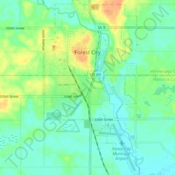
Naam: Topografische kaart Forest City, hoogte, reliëf.
Locatie: Forest City, Winnebago County, Iowa, 50436, United States (43.22488 -93.65625 43.27860 -93.61542)
Gemiddelde hoogte: 374 m
Minimale hoogte: 362 m
Maximale hoogte: 397 m
Forest City was officially founded in 1855. Formerly known as “Puckerbrush”, Robert Clark the official founder/surveyor deemed it “Forest City” because it was cut right out of the trees. It was then platted in 1856, and later incorporated on June 14, 1878. The population started to grow when immigrants from Sweden and Norway settled in the Forest City because of the similar topography. Its growth continued when city leaders convinced Minneapolis and St. Louis Railroad to come to Forest City. Although the Civil War stunted the city’s growth, many immigrants found the city attractive. Later on churches, banks, a college (Waldorf University), electricity, and the telephone turned Forest City into an ideal country town. Then in 1960, investors took over a failing travel trailer factory and created Winnebago Industries causing the population to grow exponentially. Winnebago's corporate headquarters were later relocated to Eden Prairie, Minnesota causing the population to decline. Today, Forest City’s population is around 4,200.
Andere topografische kaarten
Klik op een kaart om zijn topografie, zijn hoogte en zijn reliëf te bekijken.
Lake Mills
United States > Iowa > Winnebago County
Lake Mills, Winnebago County, Iowa, 50450, United States
Gemiddelde hoogte: 383 m