
Topografische kaart Weirton Heights
Interactieve kaart
Klik op de kaart om de hoogte weer te geven.
Over deze kaart
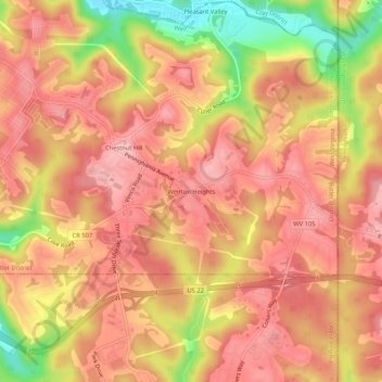
Naam: Topografische kaart Weirton Heights, hoogte, reliëf.
Gemiddelde hoogte: 332 m
Minimale hoogte: 234 m
Maximale hoogte: 378 m
Andere topografische kaarten
Klik op een kaart om zijn topografie, zijn hoogte en zijn reliëf te bekijken.
Marland Heights
United States > West Virginia > Hancock County > Weirton
Marland Heights, Weirton, Clay District, Hancock County, West Virginia, 26062, United States
Gemiddelde hoogte: 260 m
Chestnut Hill
United States > West Virginia > Hancock County > Weirton
Chestnut Hill, Weirton, Butler District, Hancock County, West Virginia, 26062, United States
Gemiddelde hoogte: 325 m
Weircrest
United States > West Virginia > Hancock County > Weirton
Weircrest, Weirton, Clay District, Hancock County, West Virginia, 26062, United States
Gemiddelde hoogte: 266 m
Pleasant Valley
United States > West Virginia > Hancock County > Weirton
Pleasant Valley, Weirton, Butler District, Hancock County, West Virginia, 26062, United States
Gemiddelde hoogte: 318 m
Weirton
United States > West Virginia > Hancock County > Weirton > Weirton
Weirton, Hancock County, West Virginia, 26062-4500, United States
Gemiddelde hoogte: 287 m