
Topografische kaart Sunni
Interactieve kaart
Klik op de kaart om de hoogte weer te geven.
Over deze kaart
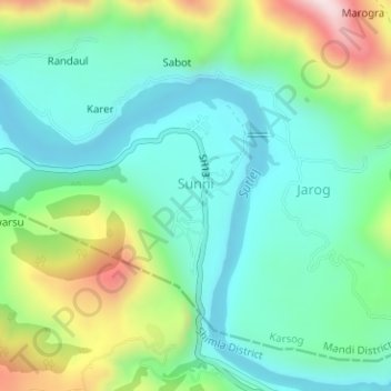
Naam: Topografische kaart Sunni, hoogte, reliëf.
Locatie: Sunni, Karsog, Mandi District, Himachal Pradesh, India (31.23710 77.11981 31.24609 77.12196)
Gemiddelde hoogte: 768 m
Minimale hoogte: 619 m
Maximale hoogte: 1.137 m
Andere topografische kaarten
Klik op een kaart om zijn topografie, zijn hoogte en zijn reliëf te bekijken.
Bajandi
India > Himachal Pradesh > Karsog
Bajandi, Karsog, Mandi District, Himachal Pradesh, 175046, India
Gemiddelde hoogte: 1.663 m
Tattapani
India > Himachal Pradesh > Karsog
Tattapani, Karsog, Mandi District, Himachal Pradesh, 175009, India
Gemiddelde hoogte: 1.056 m
Nanj
India > Himachal Pradesh > Karsog
Nanj, Karsog, Mandi, Himachal Pradesh, 172027, India
Gemiddelde hoogte: 1.156 m
Pangna
India > Himachal Pradesh > Karsog
Pangna, Karsog, Mandi, Himachal Pradesh, 175046, India
Gemiddelde hoogte: 1.640 m
Churag
India > Himachal Pradesh > Karsog > Churag
Churag, Karsog, Mandi, Himachal Pradesh, 175010, India
Gemiddelde hoogte: 1.760 m
Khanyar
India > Himachal Pradesh > Karsog
Khanyar, Karsog, Mandi, Himachal Pradesh, 175010, India
Gemiddelde hoogte: 1.662 m
Bitahli Khad
India > Himachal Pradesh > Karsog
Bitahli Khad, Karsog, Mandi, Himachal Pradesh, 175010, India
Gemiddelde hoogte: 1.431 m