Topografische kaart Jacksons" Gap
Interactieve kaart
Klik op de kaart om de hoogte weer te geven.
Over deze kaart
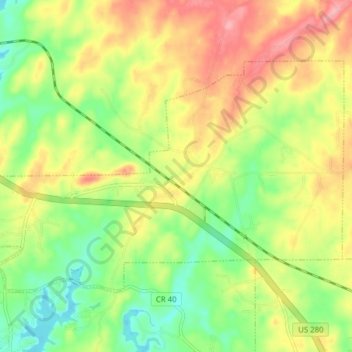
Naam: Topografische kaart Jacksons" Gap, hoogte, reliëf.
Gemiddelde hoogte: 189 m
Minimale hoogte: 140 m
Maximale hoogte: 244 m

Klik op de kaart om de hoogte weer te geven.
Naam: Topografische kaart Jacksons" Gap, hoogte, reliëf.
Gemiddelde hoogte: 189 m
Minimale hoogte: 140 m
Maximale hoogte: 244 m