
Topografische kaart Conklin
Interactieve kaart
Klik op de kaart om de hoogte weer te geven.
Over deze kaart
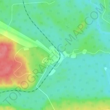
Naam: Topografische kaart Conklin, hoogte, reliëf.
Locatie: Conklin, Wood Buffalo, Alberta, T0P 1H0, Canada (55.61250 -111.10278 55.65250 -111.06278)
Gemiddelde hoogte: 571 m
Minimale hoogte: 550 m
Maximale hoogte: 623 m
Conklin is a hamlet in northern Alberta, Canada within the Regional Municipality (RM) of Wood Buffalo. It is located on Highway 881 between Fort McMurray and Lac La Biche. It lies near the west end of Christina Lake at an elevation of 575 metres (1,886 ft), and was named for John Conklin, a railroad employee.
Andere topografische kaarten
Klik op een kaart om zijn topografie, zijn hoogte en zijn reliëf te bekijken.
Christina Lake
Canada > Alberta > Wood Buffalo > Conklin
Christina Lake, Conklin, Wood Buffalo, Alberta, Canada
Gemiddelde hoogte: 573 m