
Topografische kaart Maricopa County
Interactieve kaart
Klik op de kaart om de hoogte weer te geven.
Over deze kaart
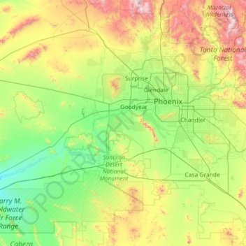
Naam: Topografische kaart Maricopa County, hoogte, reliëf.
Locatie: Maricopa County, Arizona, United States of America (32.50497 -113.33376 34.04814 -111.03990)
Gemiddelde hoogte: 549 m
Minimale hoogte: 105 m
Maximale hoogte: 2.297 m
Andere topografische kaarten
Klik op een kaart om zijn topografie, zijn hoogte en zijn reliëf te bekijken.
Santa Cruz River
United States of America > Arizona
Santa Cruz River, Pinal County, Arizona, 85231, United States of America
Gemiddelde hoogte: 497 m
Magma
United States of America > Arizona > Magma
Magma, Pinal County, Arizona, 85153, United States of America
Gemiddelde hoogte: 464 m
San Simon
United States of America > Arizona > San Simon
San Simon, Cochise County, Arizona, United States of America
Gemiddelde hoogte: 1.100 m
Apache County
United States of America > Arizona
Apache County, Arizona, United States of America
Gemiddelde hoogte: 1.926 m
Yavapai County
United States of America > Arizona
Yavapai County, Arizona, United States of America
Gemiddelde hoogte: 1.433 m