
Topografische kaart Woodstock
Interactieve kaart
Klik op de kaart om de hoogte weer te geven.
Over deze kaart
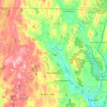
Naam: Topografische kaart Woodstock, hoogte, reliëf.
Gemiddelde hoogte: 164 m
Minimale hoogte: 68 m
Maximale hoogte: 285 m
Andere topografische kaarten
Klik op een kaart om zijn topografie, zijn hoogte en zijn reliëf te bekijken.
Plainfield
United States > Connecticut > Northeastern Connecticut Planning Region
Plainfield, Northeastern Connecticut Planning Region, Connecticut, United States
Gemiddelde hoogte: 97 m
Hampton
United States > Connecticut > Northeastern Connecticut Planning Region
Hampton, Northeastern Connecticut Planning Region, Connecticut, 06247, United States
Gemiddelde hoogte: 162 m
Sterling
United States > Connecticut > Northeastern Connecticut Planning Region
Sterling, Northeastern Connecticut Planning Region, Connecticut, United States
Gemiddelde hoogte: 131 m
Plainfield Village
United States > Connecticut > Northeastern Connecticut Planning Region > Plainfield > Plainfield Village
Plainfield Village, Plainfield, Northeastern Connecticut Planning Region, Connecticut, United States
Gemiddelde hoogte: 59 m
Scotland
United States > Connecticut > Northeastern Connecticut Planning Region
Scotland, Northeastern Connecticut Planning Region, Connecticut, 06264, United States
Gemiddelde hoogte: 116 m
Windham County
United States > Connecticut > Northeastern Connecticut Planning Region
Windham County, Northeastern Connecticut Planning Region, Connecticut, United States
Gemiddelde hoogte: 156 m