
Topografische kaart Rhinelander
Interactieve kaart
Klik op de kaart om de hoogte weer te geven.
Over deze kaart
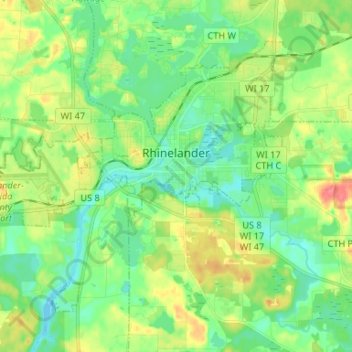
Naam: Topografische kaart Rhinelander, hoogte, reliëf.
Locatie: Rhinelander, Oneida County, Wisconsin, 54501, United States (45.59492 -89.50180 45.66587 -89.36994)
Gemiddelde hoogte: 482 m
Minimale hoogte: 462 m
Maximale hoogte: 518 m
Rhinelander has a warm-summer humid continental climate (Köppen: Dfb). Because of its location, it is prone to Arctic cold snaps, and without the western Föhn winds its winter average is lower than other places in the US at 45 °N even at high elevations. Summers tend to be cooler with some degree of Lake Superior and Lake Michigan influence. Precipitation is still relatively distributed but not as much as other humid climates in the country.
Andere topografische kaarten
Klik op een kaart om zijn topografie, zijn hoogte en zijn reliëf te bekijken.
McNaughton
United States > Wisconsin > Oneida County > Town of Newbold
McNaughton, Town of Newbold, Oneida County, Wisconsin, 54543, United States
Gemiddelde hoogte: 482 m
Hixon Lake
United States > Wisconsin > Oneida County
Hixon Lake, Town of Pelican, Oneida County, Wisconsin, United States
Gemiddelde hoogte: 484 m
Town of Hazelhurst
United States > Wisconsin > Oneida County
Town of Hazelhurst, Oneida County, Wisconsin, 54531, United States
Gemiddelde hoogte: 486 m
Town of Lake Tomahawk
United States > Wisconsin > Oneida County
Town of Lake Tomahawk, Oneida County, Wisconsin, United States
Gemiddelde hoogte: 490 m
Town of Minoqua
United States > Wisconsin > Oneida County
Town of Minoqua, Oneida County, Wisconsin, United States
Gemiddelde hoogte: 485 m
Town of Woodboro
United States > Wisconsin > Oneida County
Town of Woodboro, Oneida County, Wisconsin, United States
Gemiddelde hoogte: 477 m
Tripoli
United States > Wisconsin > Oneida County
Tripoli, Town of Lynne, Oneida County, Wisconsin, 54564, United States
Gemiddelde hoogte: 470 m
Town of Three Lakes
United States > Wisconsin > Oneida County
Town of Three Lakes, Oneida County, Wisconsin, 54562, United States
Gemiddelde hoogte: 503 m
Sugar Camp Lake
United States > Wisconsin > Oneida County > Town of Sugar Camp > Sugar Camp
Sugar Camp Lake, Sugar Camp, Town of Sugar Camp, Oneida County, Wisconsin, United States
Gemiddelde hoogte: 508 m
Prairie Lake
United States > Wisconsin > Oneida County
Prairie Lake, Town of Nokomis, Oneida County, Wisconsin, United States
Gemiddelde hoogte: 457 m
Stella Lake
United States > Wisconsin > Oneida County
Stella Lake, Town of Stella, Oneida County, Wisconsin, United States
Gemiddelde hoogte: 503 m
Stella
United States > Wisconsin > Oneida County
Stella, Town of Stella, Oneida County, Wisconsin, United States
Gemiddelde hoogte: 491 m
Norway Island
United States > Wisconsin > Oneida County
Norway Island, Town of Minoqua, Oneida County, Wisconsin, United States
Gemiddelde hoogte: 488 m
Monico
United States > Wisconsin > Oneida County > Monico
Monico, Town of Monico, Oneida County, Wisconsin, United States
Gemiddelde hoogte: 494 m
Town of Pine Lake
United States > Wisconsin > Oneida County
Town of Pine Lake, Oneida County, Wisconsin, United States
Gemiddelde hoogte: 485 m
Dam Lake
United States > Wisconsin > Oneida County > Town of Sugar Camp
Dam Lake, Town of Sugar Camp, Oneida County, Wisconsin, United States
Gemiddelde hoogte: 493 m
Pelican Lake
United States > Wisconsin > Oneida County
Pelican Lake, Town of Schoepke, Oneida County, Wisconsin, 54463, United States
Gemiddelde hoogte: 487 m
Yukon Creek
United States > Wisconsin > Oneida County
Yukon Creek, Town of Minoqua, Oneida County, Wisconsin, United States
Gemiddelde hoogte: 481 m
Minocqua
United States > Wisconsin > Oneida County
Minocqua, Town of Minoqua, Oneida County, Wisconsin, United States
Gemiddelde hoogte: 491 m
Clearwater Lake
United States > Wisconsin > Oneida County > Town of Three Lakes
Clearwater Lake, Town of Three Lakes, Oneida County, Wisconsin, United States
Gemiddelde hoogte: 500 m