
Topografische kaart Roxbury
Interactieve kaart
Klik op de kaart om de hoogte weer te geven.
Over deze kaart
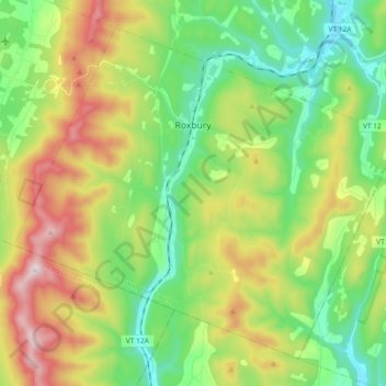
Naam: Topografische kaart Roxbury, hoogte, reliëf.
Locatie: Roxbury, Washington County, Vermont, 05669, United States (44.01281 -72.81894 44.12670 -72.63448)
Gemiddelde hoogte: 494 m
Minimale hoogte: 226 m
Maximale hoogte: 969 m
More than twenty points within the town have an elevation of more than 2,000 feet (610 m); elevations in the town range from a low of 880 feet (270 m) (along the Third Branch of the White River) to a high of 3,086 feet (941 m) (at the peak of Rice Mountain). Rice Mountain lies in the Northfield range of the Green Mountains along the western boundary of the town.
Andere topografische kaarten
Klik op een kaart om zijn topografie, zijn hoogte en zijn reliëf te bekijken.
Montpelier
United States > Vermont > Washington County
Montpelier, Washington County, Vermont, 05602, United States
Gemiddelde hoogte: 284 m
Worcester
United States > Vermont > Washington County
Worcester, Washington County, Vermont, 05682, United States
Gemiddelde hoogte: 461 m
Duxbury
United States > Vermont > Washington County
Duxbury, Washington County, Vermont, 05676, United States
Gemiddelde hoogte: 335 m
Middlesex
United States > Vermont > Washington County
Middlesex, Washington County, Vermont, United States
Gemiddelde hoogte: 331 m
Woodbury
United States > Vermont > Washington County
Woodbury, Washington County, Vermont, 05681, United States
Gemiddelde hoogte: 411 m
Adamant
United States > Vermont > Washington County > Calais
Adamant, Calais, Washington County, Vermont, 05640, United States
Gemiddelde hoogte: 365 m
East Montpelier
United States > Vermont > Washington County
East Montpelier, Washington County, Vermont, United States
Gemiddelde hoogte: 311 m
Marshfield
United States > Vermont > Washington County
Marshfield, Washington County, Vermont, 05658, United States
Gemiddelde hoogte: 403 m
Cabot
United States > Vermont > Washington County
Cabot, Washington County, Vermont, 05647, United States
Gemiddelde hoogte: 458 m
Mount Ellen
United States > Vermont > Washington County > Warren
Mount Ellen, Warren, Washington County, Vermont, United States
Gemiddelde hoogte: 906 m
Barre City
United States > Vermont > Washington County
Barre City, Washington County, Vermont, 05641, United States
Gemiddelde hoogte: 261 m
Sugarbush Village
United States > Vermont > Washington County > Warren
Sugarbush Village, Warren, Washington County, Vermont, United States
Gemiddelde hoogte: 606 m
Waterbury
United States > Vermont > Washington County > Waterbury
Waterbury, Washington County, Vermont, United States
Gemiddelde hoogte: 199 m
East Roxbury
United States > Vermont > Washington County > Roxbury
East Roxbury, Roxbury, Washington County, Vermont, United States
Gemiddelde hoogte: 470 m
Berlin
United States > Vermont > Washington County
Berlin, Washington County, Vermont, United States
Gemiddelde hoogte: 315 m
North Montpelier
United States > Vermont > Washington County > East Montpelier
North Montpelier, East Montpelier, Washington County, Vermont, 05666, United States
Gemiddelde hoogte: 278 m
North Duxbury
United States > Vermont > Washington County > Duxbury
North Duxbury, Duxbury, Washington County, Vermont, United States
Gemiddelde hoogte: 275 m
Moretown
United States > Vermont > Washington County > Moretown
Moretown, Washington County, Vermont, 05660, United States
Gemiddelde hoogte: 383 m
Waitsfield
United States > Vermont > Washington County > Waitsfield
Waitsfield, Washington County, Vermont, 05673, United States
Gemiddelde hoogte: 424 m
Plainfield
United States > Vermont > Washington County
Plainfield, Washington County, Vermont, 05667, United States
Gemiddelde hoogte: 386 m
Northfield
United States > Vermont > Washington County > Northfield
Northfield, Washington County, Vermont, 05663, United States
Gemiddelde hoogte: 298 m
Warren
United States > Vermont > Washington County
Warren, Washington County, Vermont, 05674, United States
Gemiddelde hoogte: 575 m