
Topografische kaart Grants
Interactieve kaart
Klik op de kaart om de hoogte weer te geven.
Over deze kaart
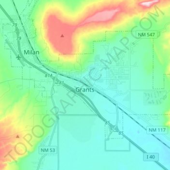
Naam: Topografische kaart Grants, hoogte, reliëf.
Locatie: Grants, Cibola County, New Mexico, 87020, United States (35.11746 -107.91069 35.18267 -107.78533)
Gemiddelde hoogte: 2.019 m
Minimale hoogte: 1.943 m
Maximale hoogte: 2.271 m
Andere topografische kaarten
Klik op een kaart om zijn topografie, zijn hoogte en zijn reliëf te bekijken.
San Fidel
United States > New Mexico > Cibola County
San Fidel, Cibola County, New Mexico, 87049, United States
Gemiddelde hoogte: 1.887 m
Milan
United States > New Mexico > Cibola County
Milan, Cibola County, New Mexico, 87021, United States
Gemiddelde hoogte: 2.036 m
El Malpais National Conservation Area
United States > New Mexico > Cibola County
El Malpais National Conservation Area, Cibola County, New Mexico, United States
Gemiddelde hoogte: 2.256 m
El Morro National Monument
United States > New Mexico > Cibola County
El Morro National Monument, Eastern Navajo Agency, Cibola County, New Mexico, United States
Gemiddelde hoogte: 2.205 m
Fence Lake
United States > New Mexico > Cibola County
Fence Lake, Cibola County, New Mexico, United States
Gemiddelde hoogte: 2.154 m
Bluewater
United States > New Mexico > Cibola County
Bluewater, Cibola County, New Mexico, 87005, United States
Gemiddelde hoogte: 2.038 m
Mount Taylor
United States > New Mexico > Cibola County
Mount Taylor, Cibola County, New Mexico, United States
Gemiddelde hoogte: 3.168 m
Mesa Colorado
United States > New Mexico > Cibola County
Mesa Colorado, Cibola County, New Mexico, United States
Gemiddelde hoogte: 2.156 m
Mesita De Yeso
United States > New Mexico > Cibola County
Mesita De Yeso, Cibola County, New Mexico, United States
Gemiddelde hoogte: 2.137 m
New York
United States > New Mexico > Cibola County > New York
New York, Cibola County, New Mexico, 87007, United States
Gemiddelde hoogte: 1.880 m
Laguna
United States > New Mexico > Cibola County
Laguna, Cibola County, New Mexico, United States
Gemiddelde hoogte: 1.804 m