
Topografische kaart Uturuncu
Interactieve kaart
Klik op de kaart om de hoogte weer te geven.
Uturuncu
At an elevation of 6,008 metres (19,711 ft), Uturuncu is the highest mountain in southwestern Bolivia. It dominates the regional geomorphology, rising about 1,510–1,670 metres (4,950–5,480 ft) above the surrounding terrain and presenting a good view of the surrounding mountains from the summit. The volcano has two summit peaks, one 5,930 metres (19,460 ft) and the other 6,008 metres (19,711 ft) high. They are about 1 kilometre (0.62 mi) apart and separated by a saddle that is 5,700 metres (18,700 ft) high. Uturuncu is a stratovolcano with remnants of a crater, and consists of lava domes and lava flows erupted from a number of vents in the central part of the volcano.
Over deze kaart
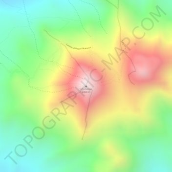
Naam: Topografische kaart Uturuncu, hoogte, reliëf.
Gemiddelde hoogte: 5.594 m
Minimale hoogte: 5.259 m
Maximale hoogte: 6.006 m