
Topografische kaart Deha
Interactieve kaart
Klik op de kaart om de hoogte weer te geven.
Over deze kaart
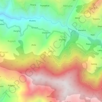
Naam: Topografische kaart Deha, hoogte, reliëf.
Locatie: Deha, Theog, Shimla District, Himachal Pradesh, India (31.02382 77.43489 31.06382 77.47489)
Gemiddelde hoogte: 2.048 m
Minimale hoogte: 1.451 m
Maximale hoogte: 2.686 m
Andere topografische kaarten
Klik op een kaart om zijn topografie, zijn hoogte en zijn reliëf te bekijken.
Dharma
India > Himachal Pradesh > Theog
Dharma, Theog, Shimla, Himachal Pradesh, 171226, India
Gemiddelde hoogte: 1.575 m
Shilaru
India > Himachal Pradesh > Theog
Shilaru, Theog, Shimla District, Himachal Pradesh, 171212, India
Gemiddelde hoogte: 2.329 m