
Topografische kaart Amherst
Interactieve kaart
Klik op de kaart om de hoogte weer te geven.
Over deze kaart
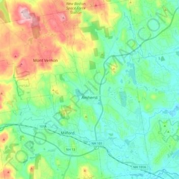
Naam: Topografische kaart Amherst, hoogte, reliëf.
Gemiddelde hoogte: 127 m
Minimale hoogte: 50 m
Maximale hoogte: 320 m
According to the United States Census Bureau, the town has a total area of 34.7 square miles (89.9 km2), of which 34.2 square miles (88.5 km2) is land and 0.54 square miles (1.4 km2), or 1.51% of the total area, is water. Located on the Souhegan River, Amherst is drained by Beaver, Bloody, and Joe English brooks. Amherst's highest point is on Chestnut Hill at the town's northern border, where the elevation reaches 865 feet (264 m) above sea level. Amherst lies fully within the Merrimack River watershed.