
Topografische kaart Isla Cozumel
Interactieve kaart
Klik op de kaart om de hoogte weer te geven.
Over deze kaart
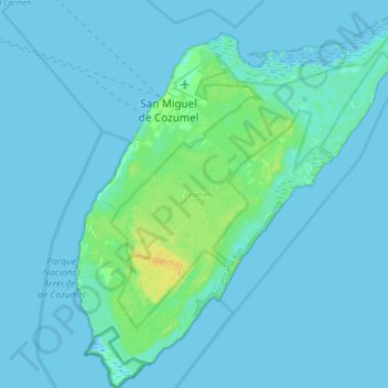
Naam: Topografische kaart Isla Cozumel, hoogte, reliëf.
Locatie: Isla Cozumel, Cozumel, Quintana Roo, Mexico (20.27200 -87.02520 20.59200 -86.72328)
Gemiddelde hoogte: 2 m
Minimale hoogte: -3 m
Maximale hoogte: 18 m
Large parts of the island are covered with mangrove forest which has many endemic animal species. Cozumel is a flat island based on limestone, resulting in a karst topography. The highest natural point on the island is less than 15 m (49 ft) above sea level. The cenotes are water-filled sinkholes formed by water percolating through the soft limestone soil for thousands of years. Eighteen deep cenotes and more than 250 shallow bodies exist on the island. Many are under dense vegetation. Jade Cavern Cozumel (Cenote Chempita) near El Cedral is often visited by tourists.
Andere topografische kaarten
Klik op een kaart om zijn topografie, zijn hoogte en zijn reliëf te bekijken.
Playa Palancar
Mexico > Quintana Roo > Cozumel > Palancar
Playa Palancar, Palancar, Cozumel, Quintana Roo, Mexico
Gemiddelde hoogte: 1 m