
Topografische kaart Lake George
Interactieve kaart
Klik op de kaart om de hoogte weer te geven.
Over deze kaart
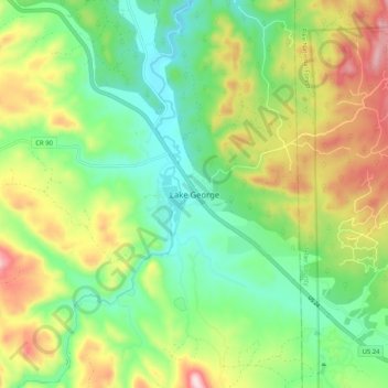
Naam: Topografische kaart Lake George, hoogte, reliëf.
Locatie: Lake George, Park County, Colorado, United States (38.94040 -105.39843 39.02040 -105.31843)
Gemiddelde hoogte: 2.543 m
Minimale hoogte: 2.397 m
Maximale hoogte: 2.790 m
About 42.3 miles (68.1 km) northwest of Colorado Springs and 7.3 miles (11.7 km) northwest of Florissant, the town of Lake George was established in 1891 as a railroad stop for the Colorado Midland Railway (CM) which had been completed in 1887. The town and nearby lake—to its west and fed by the South Platte River—The man made lake was built by George Frost for the purpose of supplying ice to the railroad. The lake, originally called George's Lake was later changed to Lake George when the post office opened. The lake itself freezes mostly solid in the wintertime, which made it ideal for railroad men to cut large blocks of ice from it in order to keep perishables cool. A privately owned ice company here supplied the needs of much of the Pikes Peak region. Ice cut during the winter was shipped on the CM to both Colorado Springs and the Cripple Creek, Colorado district. Also related to the town's railroading history, a short walk into the surrounding hills reveals Chinese bread ovens, from the period their labor was imported. At the turn of the century the community's population was 30. After 1900 some farmers and ranchers nearby began raising high-altitude potatoes on a limited scale. This furnished the CM with some additional traffic. However, the CM closed in August 1918. Other railways then provided service to certain shippers along the otherwise idle CM railway. Up to that time this had been the shortest rail route through the mountains. Keeping the track open during winter proved expensive, and when the mining of ore dwindled, the tracks were torn up. U.S. Route 24 follows the abandoned grade of the CM railway. By 1941 the community had grown to 100 persons and was the center of an extensive potato growing area. The community's population in 1965 was 100.
Andere topografische kaarten
Klik op een kaart om zijn topografie, zijn hoogte en zijn reliëf te bekijken.
Guffey
United States > Colorado > Park County
Guffey, Park County, Colorado, United States
Gemiddelde hoogte: 2.702 m
Hartsel
United States > Colorado > Park County
Hartsel, Park County, Colorado, United States
Gemiddelde hoogte: 2.731 m
South Park
United States > Colorado > Park County
South Park, Park County, Colorado, United States
Gemiddelde hoogte: 3.013 m
Topaz Mountain
United States > Colorado > Park County
Topaz Mountain, Park County, Colorado, United States
Gemiddelde hoogte: 3.368 m
Fairplay
United States > Colorado > Park County
Fairplay, Park County, Colorado, 80440, United States
Gemiddelde hoogte: 3.040 m
Fairplay
United States > Colorado > Park County
Fairplay, Park County, Colorado, 80440, United States
Gemiddelde hoogte: 3.045 m
Staunton State Park
United States > Colorado > Park County
Staunton State Park, Park County, Colorado, 80421, United States
Gemiddelde hoogte: 2.716 m
Como
United States > Colorado > Park County
Como, Park County, Colorado, United States
Gemiddelde hoogte: 2.999 m
Kenosha Pass
United States > Colorado > Park County
Kenosha Pass, Park County, Colorado, United States
Gemiddelde hoogte: 3.047 m
Bailey
United States > Colorado > Park County
Bailey, Park County, Colorado, United States
Gemiddelde hoogte: 2.596 m
Mount Bross
United States > Colorado > Park County
Mount Bross, Park County, Colorado, United States
Gemiddelde hoogte: 4.011 m
Tarryall
United States > Colorado > Park County > Tarryall
Tarryall, Park County, Colorado, United States
Gemiddelde hoogte: 2.684 m
Elevenmile State Recreation Area
United States > Colorado > Park County
Elevenmile State Recreation Area, Park County, Colorado, United States
Gemiddelde hoogte: 2.618 m
Alma
United States > Colorado > Park County
Alma, Park County, Colorado, United States
Gemiddelde hoogte: 3.212 m
Lost Creek Wilderness
United States > Colorado > Park County
Lost Creek Wilderness, Park County, Colorado, 80448, United States
Gemiddelde hoogte: 2.721 m
Elevenmile Canyon Reservoir
United States > Colorado > Park County
Elevenmile Canyon Reservoir, Park County, Colorado, United States
Gemiddelde hoogte: 2.675 m