
Topografische kaart Gefrees
Interactieve kaart
Klik op de kaart om de hoogte weer te geven.
Over deze kaart
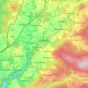
Naam: Topografische kaart Gefrees, hoogte, reliëf.
Locatie: Gefrees, Landkreis Bayreuth, Bavaria, 95482, Germany (50.04970 11.67457 50.13393 11.81840)
Gemiddelde hoogte: 585 m
Minimale hoogte: 385 m
Maximale hoogte: 851 m
Andere topografische kaarten
Klik op een kaart om zijn topografie, zijn hoogte en zijn reliëf te bekijken.
Fichtelberg
Germany > Bavaria > Landkreis Bayreuth
Fichtelberg, Landkreis Bayreuth, Bavaria, 95686, Germany
Gemiddelde hoogte: 697 m
Gottelhof
Germany > Bavaria > Landkreis Bayreuth > Hollfeld
Gottelhof, Hollfeld, Hollfeld (VGem), Landkreis Bayreuth, Bavaria, 95515, Germany
Gemiddelde hoogte: 407 m
Röhrig
Germany > Bavaria > Landkreis Bayreuth > Bindlacher Berg
Röhrig, Bindlacher Berg, Bindlach, Landkreis Bayreuth, Bavaria, 95463, Germany
Gemiddelde hoogte: 410 m
Plech
Germany > Bavaria > Landkreis Bayreuth
Plech, Betzenstein (VGem), Landkreis Bayreuth, Bavaria, 91287, Germany
Gemiddelde hoogte: 475 m