
Topografische kaart Creve Coeur
Interactieve kaart
Klik op de kaart om de hoogte weer te geven.
Over deze kaart
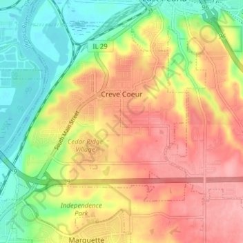
Naam: Topografische kaart Creve Coeur, hoogte, reliëf.
Locatie: Creve Coeur, Tazewell County, Illinois, 61610, United States (40.62213 -89.63710 40.66144 -89.57393)
Gemiddelde hoogte: 185 m
Minimale hoogte: 132 m
Maximale hoogte: 234 m
Andere topografische kaarten
Klik op een kaart om zijn topografie, zijn hoogte en zijn reliëf te bekijken.
North Pekin
United States > Illinois > Tazewell County
North Pekin, Tazewell County, Illinois, United States
Gemiddelde hoogte: 152 m
Washington
United States > Illinois > Tazewell County
Washington, Tazewell County, Illinois, 61571, United States
Gemiddelde hoogte: 236 m
Morton
United States > Illinois > Tazewell County
Morton, Tazewell County, Illinois, 61550, United States
Gemiddelde hoogte: 219 m
East Peoria
United States > Illinois > Tazewell County
East Peoria, Tazewell County, Illinois, 61611, United States
Gemiddelde hoogte: 176 m
Pekin
United States > Illinois > Tazewell County
Pekin, Tazewell County, Illinois, 61554, United States
Gemiddelde hoogte: 157 m
Minier
United States > Illinois > Tazewell County
Minier, Tazewell County, Illinois, United States
Gemiddelde hoogte: 195 m
Hopedale
United States > Illinois > Tazewell County
Hopedale, Tazewell County, Illinois, United States
Gemiddelde hoogte: 195 m
Green Valley
United States > Illinois > Tazewell County
Green Valley, Tazewell County, Illinois, United States
Gemiddelde hoogte: 164 m
Mackinaw
United States > Illinois > Tazewell County
Mackinaw, Tazewell County, Illinois, United States
Gemiddelde hoogte: 198 m