
Topografische kaart Tynda
Interactieve kaart
Klik op de kaart om de hoogte weer te geven.
Over deze kaart
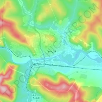
Naam: Topografische kaart Tynda, hoogte, reliëf.
Gemiddelde hoogte: 566 m
Minimale hoogte: 477 m
Maximale hoogte: 766 m
The town is located at an elevation of 500 meters (1,600 ft) above sea level, near where the Getkan joins the Tynda River, after which the town was named. The Tynda then flows into the Gilyuy, a tributary of the Zeya, a few kilometers east of the town.