
Topografische kaart Naucalpan
Interactieve kaart
Klik op de kaart om de hoogte weer te geven.
Over deze kaart
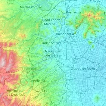
Naam: Topografische kaart Naucalpan, hoogte, reliëf.
Gemiddelde hoogte: 2.459 m
Minimale hoogte: 2.223 m
Maximale hoogte: 3.514 m
The highest peaks are the Organo and La Malinche mountains at 3,650 metres (11,980 feet) above sea level. Other notable elevations include la Cantera, El Cedral, San Joselito, La Plantación and Peña del Rayo. The main rivers through the area include the Totolina, San Lorenzo and Los Remedios. Water supply for the municipality is supplemented by 28 deep wells, and an aqueduct that brings water from the Lerma River. It has a temperate climate with a rainy season in the summer and early fall. Freezing temperatures occur between November and February, but the last significant snowfall occurred in 1967. Vegetation outside the city proper consists of conifers and oaks, with orchards of fruit trees such as plums, apples and pears. Most wildlife consists of small mammals such as squirrels and opossums along with small reptiles and birds. However, deforestation is a major problem. There are eight ejidos, five of which are dedicated to agriculture and the rest to other activities. Agricultural production includes animal feed, barley, beans, corn, wheat, avocados, peaches and cactus fruit. Livestock includes cattle, pigs, sheep and domestic fowl. There is also some trout farming. Building stone, sand and gravel are still mined here. However, the overwhelming majority of the municipality's economic activity is the industry and commerce in the city proper.