Geolokaliseren

Topografische kaart Dörrebach

Interactieve kaart

Klik op de kaart om de hoogte weer te geven.

Over deze kaart

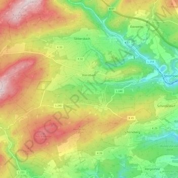
Naam: Topografische kaart Dörrebach, hoogte, reliëf.

Locatie: Dörrebach, Langenlonsheim-Stromberg, Landkreis Bad Kreuznach, Rhineland-Palatinate, 55444, Germany (49.92189 7.65060 49.95625 7.77003)

Gemiddelde hoogte: 410 m

Minimale hoogte: 219 m

Maximale hoogte: 647 m

Dörrebach lies in the northeast of the Soonwald, which is part of the Hunsrück not far from the seam where it meets the Binger Wald (forest). The Soonwald stretches out between the Guldenbach and the Simmerbach and with an area of 25 000 ha is after the Palatinate Forest western Germany’s second biggest contiguous woodland. In this sanctuary for red deer has been not only the Jäger aus Kurpfalz (“Hunter from Electoral Palatinate”, the subject of a well known folksong), but also the Hunsrück “national hero” – actually a robber – known as Schinderhannes, who made the place his hideout. Northwest of the village, beyond the Hochsteinchen (a mountain) lies Rheinböllen, while to the southeast lies Stromberg. Dörrebach lies on the northwest side of the widely wooded and hilly Bad Kreuznach district, and also within the influence of the middle centres of Bad Kreuznach and Bingen. The municipal area measures 13.14 km² (of which 2.36 km² is wooded) and has an average elevation of 370 m above sea level, while the municipality’s highest elevation, called the Kipp, is 408.3 m above sea level. Given over to agriculture is an area of 320 ha, of which 180 ha is grassland and the other 140 ha is cropfields.

Wikipedia (CC-BY-SA 3.0)

Andere topografische kaarten

Klik op een kaart om zijn topografie, zijn hoogte en zijn reliëf te bekijken.

Langenlonsheim

Germany > Rhineland-Palatinate > Landkreis Bad Kreuznach

Langenlonsheim, Langenlonsheim-Stromberg, Landkreis Bad Kreuznach, Rhineland-Palatinate, Germany

Gemiddelde hoogte: 135 m

Sponheim

Germany > Rhineland-Palatinate > Landkreis Bad Kreuznach

Sponheim, Rüdesheim, Landkreis Bad Kreuznach, Rhineland-Palatinate, Germany

Gemiddelde hoogte: 280 m

Meddersheim

Germany > Rhineland-Palatinate > Landkreis Bad Kreuznach

Meddersheim, Nahe-Glan, Landkreis Bad Kreuznach, Rhineland-Palatinate, Germany

Gemiddelde hoogte: 228 m

Seesbach

Germany > Rhineland-Palatinate > Landkreis Bad Kreuznach

Seesbach, Nahe-Glan, Landkreis Bad Kreuznach, Rhineland-Palatinate, 55629, Germany

Gemiddelde hoogte: 385 m

Bad Kreuznach

Germany > Rhineland-Palatinate > Landkreis Bad Kreuznach

Bad Kreuznach, Landkreis Bad Kreuznach, Rhineland-Palatinate, Germany

Gemiddelde hoogte: 180 m

Kirn

Germany > Rhineland-Palatinate > Landkreis Bad Kreuznach

Kirn, Kirner Land, Landkreis Bad Kreuznach, Rhineland-Palatinate, Germany

Gemiddelde hoogte: 302 m

Gutenberg

Germany > Rhineland-Palatinate > Landkreis Bad Kreuznach

Gutenberg, Rüdesheim, Landkreis Bad Kreuznach, Rhineland-Palatinate, Germany

Gemiddelde hoogte: 214 m