
Topografische kaart Coos Bay
Interactieve kaart
Klik op de kaart om de hoogte weer te geven.
Over deze kaart
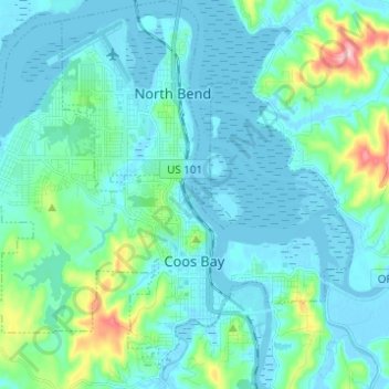
Naam: Topografische kaart Coos Bay, hoogte, reliëf.
Locatie: Coos Bay, Coos County, Oregon, 97420, United States (43.34296 -124.29044 43.42319 -124.16729)
Gemiddelde hoogte: 30 m
Minimale hoogte: -4 m
Maximale hoogte: 209 m
According to the United States Census Bureau, the city has a total area of 15.90 square miles (41.18 km2), of which, 10.60 square miles (27.45 km2) is land and 5.30 square miles (13.73 km2) is water. The city is quite hilly, with elevations ranging from between sea level to over 500 feet (150 m). Bodies of water within the city limits include Upper Pony Creek Reservoir, Lake Merritt, Empire Lakes and numerous streams.
Andere topografische kaarten
Klik op een kaart om zijn topografie, zijn hoogte en zijn reliëf te bekijken.
Whiskey Run Beach
United States > Oregon > Coos County
Whiskey Run Beach, Coos County, Oregon, United States
Gemiddelde hoogte: 22 m
Coquille
United States > Oregon > Coos County
Coquille, Coos County, Oregon, United States
Gemiddelde hoogte: 40 m
North Bend
United States > Oregon > Coos County > North Bend
North Bend, Coos County, Oregon, United States
Gemiddelde hoogte: 11 m
Bandon
United States > Oregon > Coos County
Bandon, Coos County, Oregon, United States
Gemiddelde hoogte: 22 m