
Topografische kaart Royal Pines
Interactieve kaart
Klik op de kaart om de hoogte weer te geven.
Over deze kaart
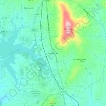
Naam: Topografische kaart Royal Pines, hoogte, reliëf.
Gemiddelde hoogte: 700 m
Minimale hoogte: 637 m
Maximale hoogte: 903 m
Royal Pines is located in southern Buncombe County at 35°28′39″N 82°30′35″W / 35.47750°N 82.50972°W / 35.47750; -82.50972 (35.477386, -82.509833). It is bordered to the west by U.S. Route 25A and the city limits of Asheville, and to the northeast by Mills Gap Road. Brown Mountain, with an elevation of 2,996 feet (913 m), occupies the center of the CDP.
Andere topografische kaarten
Klik op een kaart om zijn topografie, zijn hoogte en zijn reliëf te bekijken.
Biltmore Village
United States > North Carolina > Buncombe County > Asheville
Biltmore Village, Asheville, Buncombe County, North Carolina, 28802, United States
Gemiddelde hoogte: 642 m
Albemarle
United States > North Carolina > Buncombe County > Asheville
Albemarle, Asheville, Buncombe County, North Carolina, 28802, United States
Gemiddelde hoogte: 718 m
Biltmore
United States > North Carolina > Buncombe County > Asheville
Biltmore, Asheville, Buncombe County, North Carolina, 28803, United States
Gemiddelde hoogte: 650 m
Redwood Village
United States > North Carolina > Buncombe County > Asheville
Redwood Village, Asheville, Buncombe County, North Carolina, 28805, United States
Gemiddelde hoogte: 657 m
Aston Park
United States > North Carolina > Buncombe County > Asheville > River Arts District
Aston Park, River Arts District, Asheville, Buncombe County, North Carolina, 28801, United States
Gemiddelde hoogte: 641 m
Kenilworth
United States > North Carolina > Buncombe County > Asheville
Kenilworth, Asheville, Buncombe County, North Carolina, 28802, United States
Gemiddelde hoogte: 648 m
Deaver View
United States > North Carolina > Buncombe County > Asheville
Deaver View, Asheville, Buncombe County, North Carolina, 28806, United States
Gemiddelde hoogte: 678 m