
Topografische kaart Damdim
Interactieve kaart
Klik op de kaart om de hoogte weer te geven.
Over deze kaart
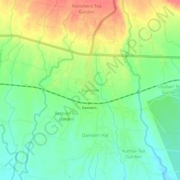
Naam: Topografische kaart Damdim, hoogte, reliëf.
Locatie: Damdim, Mal, Jalpaiguri District, West Bengal, 735209, India (26.84182 88.65047 26.88182 88.69047)
Gemiddelde hoogte: 161 m
Minimale hoogte: 135 m
Maximale hoogte: 195 m
Dam Dim is located at 26°51′56″N 88°40′11″E / 26.8656°N 88.6698°E / 26.8656; 88.6698 at an elevation of 141 m above MSL.
Andere topografische kaarten
Klik op een kaart om zijn topografie, zijn hoogte en zijn reliëf te bekijken.
Manabari
India > West Bengal > Mal
Manabari, Mal, Jalpaiguri District, West Bengal, 735222, India
Gemiddelde hoogte: 196 m
Manabari Tea Garden
India > West Bengal > Mal
Manabari Tea Garden, Mal, Jalpaiguri District, West Bengal, 735222, India
Gemiddelde hoogte: 167 m