
Topografische kaart Collettsville
Interactieve kaart
Klik op de kaart om de hoogte weer te geven.
Over deze kaart
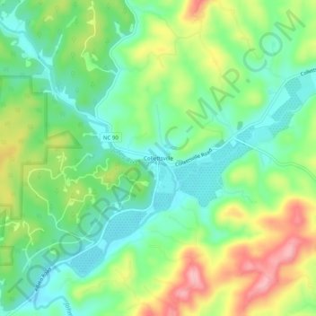
Naam: Topografische kaart Collettsville, hoogte, reliëf.
Gemiddelde hoogte: 378 m
Minimale hoogte: 324 m
Maximale hoogte: 471 m
Andere topografische kaarten
Klik op een kaart om zijn topografie, zijn hoogte en zijn reliëf te bekijken.
Lenoir
United States > North Carolina > Caldwell County
Lenoir, Caldwell County, North Carolina, 28645, United States
Gemiddelde hoogte: 381 m
Patterson
United States > North Carolina > Caldwell County
Patterson, Caldwell County, North Carolina, United States
Gemiddelde hoogte: 450 m
Buffalo Cove
United States > North Carolina > Caldwell County
Buffalo Cove, Caldwell County, North Carolina, United States
Gemiddelde hoogte: 529 m
Brown Mountain Beach
United States > North Carolina > Caldwell County
Brown Mountain Beach, Caldwell County, North Carolina, United States
Gemiddelde hoogte: 423 m
Cedar Rock Estates
United States > North Carolina > Caldwell County > Lenoir
Cedar Rock Estates, Lenoir, Caldwell County, North Carolina, United States
Gemiddelde hoogte: 441 m
Grassy Knob
United States > North Carolina > Caldwell County > Lenoir
Grassy Knob, Lenoir, Caldwell County, North Carolina, United States
Gemiddelde hoogte: 412 m
Gamewell
United States > North Carolina > Caldwell County > Gamewell
Gamewell, Caldwell County, North Carolina, United States
Gemiddelde hoogte: 346 m
Grand View Park
United States > North Carolina > Caldwell County > Lenoir > Grand View Park
Grand View Park, Lenoir, Caldwell County, North Carolina, 8645, United States
Gemiddelde hoogte: 348 m