
Topografische kaart Bayeux
Interactieve kaart
Klik op de kaart om de hoogte weer te geven.
Over deze kaart
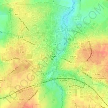
Naam: Topografische kaart Bayeux, hoogte, reliëf.
Locatie: Bayeux, Calvados, Normandy, Metropolitan France, 14400, France (49.26081 -0.72757 49.29347 -0.67574)
Gemiddelde hoogte: 55 m
Minimale hoogte: 30 m
Maximale hoogte: 73 m
Bayeux is located 7 kilometres (4 miles) from the coast of the English Channel and 30 km (19 mi) north-west of Caen. The city, with elevations varying from 32 to 67 metres (105 to 220 feet) above sea level – with an average of 46 metres (151 feet) – is bisected by the River Aure. Bayeux is located at the crossroads of RN 13 and the train route Paris-Caen-Cherbourg. The city is the capital of the Bessin, which extends north-west of Calvados. Bayeux station has rail connections to Caen, Cherbourg, Granville and Paris.
Andere topografische kaarten
Klik op een kaart om zijn topografie, zijn hoogte en zijn reliëf te bekijken.
Omaha Beach
France > Normandy > Calvados > Vierville-sur-Mer
Omaha Beach, Hamel au Prêtre, Vierville-sur-Mer, Bayeux, Calvados, Normandy, Metropolitan France, 14710, France
Gemiddelde hoogte: 21 m
Juno Beach
France > Normandy > Calvados > Courseulles-sur-Mer
Juno Beach, Avenue des Essarts, Courseulles-sur-Mer, Caen, Calvados, Normandy, Metropolitan France, 14470, France
Gemiddelde hoogte: 4 m
Beuvron-en-Auge
Beuvron-en-Auge, Lisieux, Calvados, Normandy, Metropolitan France, 14430, France
Gemiddelde hoogte: 39 m
Beaumesnil
Beaumesnil, Vire, Calvados, Normandy, Metropolitan France, 14380, France
Gemiddelde hoogte: 110 m
Colombelles
Colombelles, Caen, Calvados, Normandy, Metropolitan France, 14460, France
Gemiddelde hoogte: 25 m
Villers-sur-Mer
Villers-sur-Mer, Lisieux, Calvados, Normandy, Metropolitan France, 14640, France
Gemiddelde hoogte: 67 m
Condé-en-Normandie
Condé-en-Normandie, Vire, Calvados, Normandy, Metropolitan France, France
Gemiddelde hoogte: 161 m
Condé-sur-Noireau
France > Normandy > Calvados > Condé-en-Normandie
Condé-sur-Noireau, Condé-en-Normandie, Vire, Calvados, Normandy, Metropolitan France, 14110, France
Gemiddelde hoogte: 130 m
Benerville-sur-Mer
Benerville-sur-Mer, Lisieux, Calvados, Normandy, Metropolitan France, 14910, France
Gemiddelde hoogte: 18 m
Trouville-sur-Mer
Trouville-sur-Mer, Lisieux, Calvados, Normandy, Metropolitan France, 14360, France
Gemiddelde hoogte: 27 m
Saint-Lambert
Saint-Lambert, Caen, Calvados, Normandy, Metropolitan France, 14570, France
Gemiddelde hoogte: 180 m
Hérouville-Saint-Clair
Hérouville-Saint-Clair, Caen, Calvados, Normandy, Metropolitan France, 14200, France
Gemiddelde hoogte: 34 m
Pont-l'Évêque
Pont-l'Évêque, Lisieux, Calvados, Normandy, Metropolitan France, 14130, France
Gemiddelde hoogte: 43 m
Saint-Sylvain
Saint-Sylvain, Caen, Calvados, Normandy, Metropolitan France, 14190, France
Gemiddelde hoogte: 65 m
Ouistreham
Ouistreham, Caen, Calvados, Normandy, Metropolitan France, 14150, France
Gemiddelde hoogte: 12 m
Arromanches-les-Bains
Arromanches-les-Bains, Bayeux, Calvados, Normandy, Metropolitan France, 14117, France
Gemiddelde hoogte: 30 m
Port-en-Bessin-Huppain
Port-en-Bessin-Huppain, Bayeux, Calvados, Normandy, Metropolitan France, 14520, France
Gemiddelde hoogte: 29 m
La Vespière-Friardel
La Vespière-Friardel, Lisieux, Calvados, Normandy, Metropolitan France, 14290, France
Gemiddelde hoogte: 173 m
Pointe du Hoc
France > Normandy > Calvados > Cricqueville-en-Bessin > Le Pont du Hable
Pointe du Hoc, Voie Verte de la Liberté, Le Pont du Hable, Cricqueville-en-Bessin, Bayeux, Calvados, Normandy, Metropolitan France, 14450, France
Gemiddelde hoogte: 12 m
Vire
France > Normandy > Calvados > Vire Normandie
Vire, Vire Normandie, Vire, Calvados, Normandy, Metropolitan France, 14500, France
Gemiddelde hoogte: 156 m
Courseulles-sur-Mer
Courseulles-sur-Mer, Caen, Calvados, Normandy, Metropolitan France, 14470, France
Gemiddelde hoogte: 19 m
Livarot
France > Normandy > Calvados > Livarot-Pays-d'Auge
Livarot, Livarot-Pays-d'Auge, Lisieux, Calvados, Normandy, Metropolitan France, 14140, France
Gemiddelde hoogte: 128 m