
Topografische kaart Chilcuautla
Interactieve kaart
Klik op de kaart om de hoogte weer te geven.
Over deze kaart
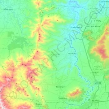
Naam: Topografische kaart Chilcuautla, hoogte, reliëf.
Locatie: Chilcuautla, Hidalgo, 42752, México (20.23877 -99.35952 20.41677 -99.15565)
Gemiddelde hoogte: 2.062 m
Minimale hoogte: 1.758 m
Maximale hoogte: 2.827 m
Andere topografische kaarten
Klik op een kaart om zijn topografie, zijn hoogte en zijn reliëf te bekijken.
Santa Rita
México > Hidalgo > Chilcuautla > Santa Ana Batha
Santa Rita, Santa Ana Batha, Chilcuautla, Hidalgo, México
Gemiddelde hoogte: 1.942 m
Cerro del Elefante
México > Hidalgo > Chilcuautla
Cerro del Elefante, Chilcuautla, Hidalgo, 42752, México
Gemiddelde hoogte: 2.146 m
El Dadhó
México > Hidalgo > Chilcuautla > El Dadhó
El Dadhó, Chilcuautla, Hidalgo, México
Gemiddelde hoogte: 1.876 m