
Topografische kaart Fayetteville
Interactieve kaart
Klik op de kaart om de hoogte weer te geven.
Over deze kaart
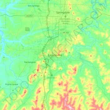
Naam: Topografische kaart Fayetteville, hoogte, reliëf.
Gemiddelde hoogte: 404 m
Minimale hoogte: 310 m
Maximale hoogte: 674 m
...yet I venture the assertion that nowhere in said country—or for that matter, in any part of the state—could be found a lovelier elevation, or a lovelier grove of graceful oaks, or a more commanding view, or, in fine, a spot better suited and adapted for the purposes designated than the one chosen for said University site and farm.
Andere topografische kaarten
Klik op een kaart om zijn topografie, zijn hoogte en zijn reliëf te bekijken.
South Mountain
United States > Arkansas > Washington County > Fayetteville
South Mountain, Fayetteville, Washington County, Arkansas, 72701, United States
Gemiddelde hoogte: 405 m
Washington Mountain
United States > Arkansas > Washington County > Fayetteville
Washington Mountain, Fayetteville, Washington County, Arkansas, United States
Gemiddelde hoogte: 409 m