
Topografische kaart Provo
Interactieve kaart
Klik op de kaart om de hoogte weer te geven.
Over deze kaart
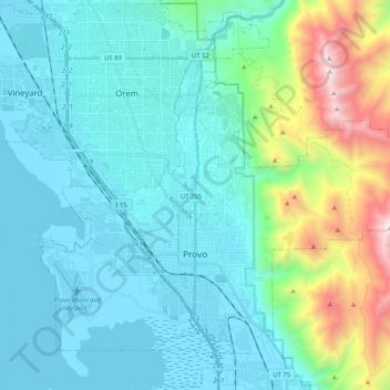
Naam: Topografische kaart Provo, hoogte, reliëf.
Locatie: Provo, Utah County, Utah, United States (40.18580 -111.74096 40.32880 -111.53687)
Gemiddelde hoogte: 1.728 m
Minimale hoogte: 1.364 m
Maximale hoogte: 3.356 m
Provo lies in the Utah Valley at an elevation of 4,549 feet (1,387 m). According to the United States Census Bureau, the city has an area of 44.2 square miles (114.4 km2), of which 41.7 square miles (107.9 km2) is land and 2.5 square miles (6.5 km2), or 5.66%, is water.