
Topografische kaart Crystal Lake
Interactieve kaart
Klik op de kaart om de hoogte weer te geven.
Over deze kaart
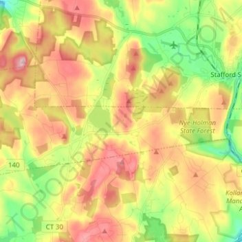
Naam: Topografische kaart Crystal Lake, hoogte, reliëf.
Gemiddelde hoogte: 213 m
Minimale hoogte: 113 m
Maximale hoogte: 315 m
The CDP is home to Crystal Lake, a 187-acre (76 ha) lake that straddles the border between Ellington and Stafford. Most of the lake shore is occupied by private residences, but there is a small public beach called Sandy Beach on the south side of the lake. The lake has an average depth of 20 feet (6.1 m), a maximum depth of 50 feet (15 m) and an elevation of 637 feet (194 m).